
Make a donation
Gear up for your next adventure:
As an Amazon Associate, this site earns from qualifying purchases at no extra cost to you.
Nongsa topographic map
Click on the map to display elevation.
Make a donation
Gear up for your next adventure:
As an Amazon Associate, this site earns from qualifying purchases at no extra cost to you.
About this map
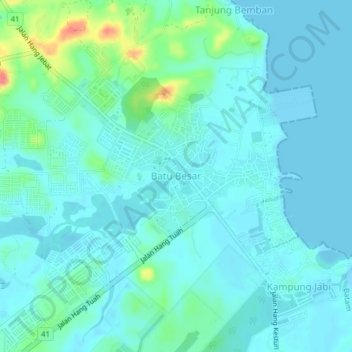
Name: Nongsa topographic map, elevation, terrain.
Location: Batu Besar, Nongsa, Riau Islands, 29467, Indonesia (1.13268 104.10863 1.17268 104.14863)
Average elevation: 12 m
Minimum elevation: -2 m
Maximum elevation: 70 m
Make a donation
Gear up for your next adventure:
As an Amazon Associate, this site earns from qualifying purchases at no extra cost to you.
Other topographic maps
Click on a map to view its topography, its elevation and its terrain.
Natuna
The airport resides at an elevation of 2 metres (6 ft 7 in) above mean sea level. It has one runway designated 18/36 with an asphalt surface measuring 2,560 m x 32 m (8,399 ft × 105 ft). The runway is planned to be widened to 80 m in 2020. Moreover, the airport has an apron measuring 120 m x 60 m and a…
Average elevation: 1 m