Geolocate

Sempolan topographic map

Click on the map to display elevation.

About this map

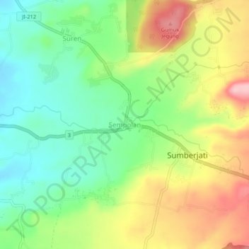
Name: Sempolan topographic map, elevation, terrain.

Location: Sempolan, Jember, East Java, Java, Indonesia (-8.19960 113.84205 -8.15960 113.88205)

Average elevation: 327 m

Minimum elevation: 254 m

Maximum elevation: 430 m

Gear up for your next adventure:

🧴Insect Repellent - Protect yourself from bugs during outdoor adventures
Backpacking Tent - Lightweight tent for long-distance hiking trips
Bushcraft Tarp - Versatile emergency shelter or gear protection
🥾Mountain Hiking Boots - High-traction boots for rocky terrain
Camping Essentials - All-in-one gear for a comfortable camping trip

As an Amazon Associate, this site earns from qualifying purchases at no extra cost to you.