
Hendek topographic map
Click on the map to display elevation.
About this map
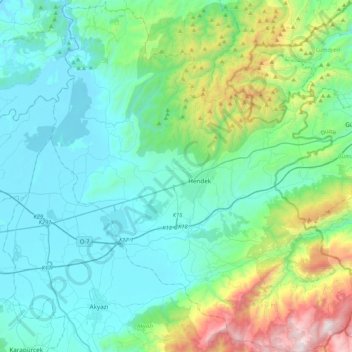
Name: Hendek topographic map, elevation, terrain.
Location: Hendek, Sakarya, Marmara Region, 54300, Turkey (40.63987 30.56703 40.95799 30.94149)
Average elevation: 376 m
Minimum elevation: 12 m
Maximum elevation: 1,724 m
Other topographic maps
Click on a map to view its topography, its elevation and its terrain.
Gaziantep
The plan introduced several important changes to the city's transportation network. One of the most important was the addition of a rail line to connect Gaziantep to the national rail system. Up to now, Turkish railway construction had ignored Gaziantep (partly because of its mountainous surroundings); a…
Average elevation: 880 m
Mihalıççık
Turkey > Mihalıççık > Mihalıççık
Mihalıççık, also Mihalıçcık (English: Micalizo, sometimes Mihaliccik), is a town and district of Eskişehir Province in the Central Anatolia region of Turkey. According to 2010 census, population of the district is 10,482 of which 3,133 live in the town of Mihalıççık. The district covers an area of…
Average elevation: 1,284 m