Geolocate

Dedem topographic map

Click on the map to display elevation.

About this map

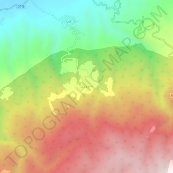
Name: Dedem topographic map, elevation, terrain.

Location: Dedem, Tosya, Kastamonu, Black Sea Region, Turkey (40.95666 34.13781 40.99666 34.17781)

Average elevation: 1,051 m

Minimum elevation: 520 m

Maximum elevation: 1,585 m

Gear up for your next adventure:

🥾Mountaineering Boots - Supportive boots for climbing and high-altitude hiking
🔋Emergency Crank Radio - Weather alerts and power without needing batteries
🧼Travel Hand Sanitizer - Keep hands clean when water is scarce
🧦Thermal Socks - Warm socks for winter hiking or camping
🧳Compression Sacks - Maximize space in your backpack by shrinking gear

As an Amazon Associate, this site earns from qualifying purchases at no extra cost to you.