Geolocate

Kalkan topographic map

Click on the map to display elevation.

About this map

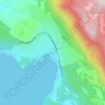
Name: Kalkan topographic map, elevation, terrain.

Location: Kalkan, Kaş, Antalya, Mediterranean Region, 07960, Turkey (36.24527 29.39526 36.28527 29.43526)

Average elevation: 267 m

Minimum elevation: 0 m

Maximum elevation: 950 m

Gear up for your next adventure:

🥘Camping Cookware Set - Compact nesting pots and pans for trail cooking
🔦UV Flashlight - Detect minerals or specific insects in the dark
🌡️Emergency Mylar Blankets - Compact thermal protection for unexpected nights outdoors
🏃Hydration Running Vest - Carry water and maps close to your body for speed
🧢Outdoor Visor - Breathable visor for sunny hikes

As an Amazon Associate, this site earns from qualifying purchases at no extra cost to you.