
Thank you for supporting this site ❤️
Make a donation
Make a donation
Gear up for your next adventure:
As an Amazon Associate, this site earns from qualifying purchases at no extra cost to you.
Oğlakçı topographic map
Click on the map to display elevation.
Thank you for supporting this site ❤️
Make a donation
Make a donation
Gear up for your next adventure:
As an Amazon Associate, this site earns from qualifying purchases at no extra cost to you.
About this map
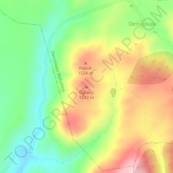
Name: Oğlakçı topographic map, elevation, terrain.
Location: Oğlakçı, Yahyalı, Central Anatolia Region, Turkey (38.15337 35.49927 38.15347 35.49937)
Average elevation: 1,460 m
Minimum elevation: 1,350 m
Maximum elevation: 1,594 m
Thank you for supporting this site ❤️
Make a donation
Make a donation
Gear up for your next adventure:
As an Amazon Associate, this site earns from qualifying purchases at no extra cost to you.