
Make a donation
Gear up for your next adventure:
As an Amazon Associate, this site earns from qualifying purchases at no extra cost to you.
Çiftlik topographic map
Click on the map to display elevation.
Make a donation
Gear up for your next adventure:
As an Amazon Associate, this site earns from qualifying purchases at no extra cost to you.
About this map
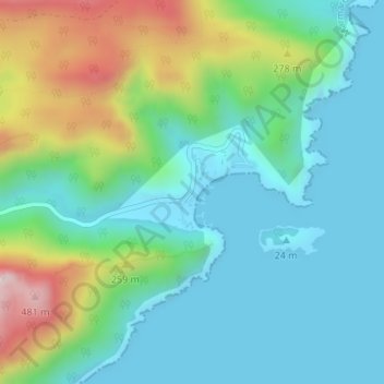
Name: Çiftlik topographic map, elevation, terrain.
Location: Çiftlik, Ilgin, Marmaris, Muğla, Aegean Region, Turkey (36.70691 28.22698 36.72691 28.24698)
Average elevation: 139 m
Minimum elevation: -2 m
Maximum elevation: 518 m
Make a donation
Gear up for your next adventure:
As an Amazon Associate, this site earns from qualifying purchases at no extra cost to you.
Other topographic maps
Click on a map to view its topography, its elevation and its terrain.
Ordu
Ordu is a strip of Black Sea coast and the hills behind, historically an agricultural and fishing area and in recent years, tourism has seen an increase, mainly visitors from Russia and Georgia, as Ordu boasts some of the best beaches, rivers, and lush, green mountains on the Black Sea coast. Walking in the…
Average elevation: 705 m
Erdek
Erdek (formerly known as Artàke, Greek: Αρτάκη) is a municipality and district of Balıkesir Province, Turkey. Its area is 307 km2, and its population is 31,902 (2022). Located on the Kapıdağ Peninsula, on the north coast of the Gulf of Erdek at the south of the Sea of Marmara, Erdek is a popular…
Average elevation: 68 m
Make a donation
Gear up for your next adventure:
As an Amazon Associate, this site earns from qualifying purchases at no extra cost to you.
Adana
Aladağlar National Park, located north of Adana, is a huge park of around 55,000 hectares, the summit of Demirkazik at 3756m is the highest point in the middle Taurus mountain range. There is a huge range of flora and fauna, and visitors may fish in the streams full of trout. Wildlife includes wild goats,…
Average elevation: 879 m
Make a donation
Gear up for your next adventure:
As an Amazon Associate, this site earns from qualifying purchases at no extra cost to you.
Devrek
Devrek is located in an altitude of 86 meters. It is 56 km from Zonguldak, 210 km from Ankara and 370 km from Istanbul. It is surrounded by mountains, the most notable ones being Babadağı, Göldağı, Akçasu and Yenice. The most important river passing through the region is Devrek creek. Devrek creek joins…
Average elevation: 577 m
Make a donation
Gear up for your next adventure:
As an Amazon Associate, this site earns from qualifying purchases at no extra cost to you.
Make a donation
Gear up for your next adventure:
As an Amazon Associate, this site earns from qualifying purchases at no extra cost to you.
Make a donation
Gear up for your next adventure:
As an Amazon Associate, this site earns from qualifying purchases at no extra cost to you.
Make a donation
Gear up for your next adventure:
As an Amazon Associate, this site earns from qualifying purchases at no extra cost to you.
Kaş
As the tenth most populous district of Antalya as of 2022, Kaş is on a hill running down to the Turquoise Coast of southwestern Turkey. The district has a typical Mediterranean climate of hot, dry summers and mild, wet winters, which allows the growth of oranges, lemons and bananas. The lowland areas are also…
Average elevation: 837 m
Ardahan
Ardahan province is located in the far north east of Turkey, where the eastern extremity of the high plateau of Eastern Anatolia converges with the Lesser Caucasus mountain range. It is consequently an area of very high altitude and severe winters. This is attractive open countryside which however spends many…
Average elevation: 2,008 m
Make a donation
Gear up for your next adventure:
As an Amazon Associate, this site earns from qualifying purchases at no extra cost to you.
Make a donation
Gear up for your next adventure:
As an Amazon Associate, this site earns from qualifying purchases at no extra cost to you.
Make a donation
Gear up for your next adventure:
As an Amazon Associate, this site earns from qualifying purchases at no extra cost to you.
Make a donation
Gear up for your next adventure:
As an Amazon Associate, this site earns from qualifying purchases at no extra cost to you.
Make a donation
Gear up for your next adventure:
As an Amazon Associate, this site earns from qualifying purchases at no extra cost to you.
Batman
The province occupies an area of 4,477 km2 (1,729 sq mi). It lies in a mountainous area with the average elevation of 550 meters which contains several thousands of caves. The tallest mountains are Sason Dağları (2500 m), Meleto (2967 m), Kuşaklı Dağı (1947 m), Avcı Dağı (2121 m), Meydanok Tepesi…
Average elevation: 941 m
Zile
Zile covers an area of 1,512 square kilometres (584 sq mi) within its city limits and has an elevation of 710 metres (2,330 ft). Turhal, Çekerek, Artova, Kadışehri, and Amasya are all towns located near Zile. The city is mostly surrounded by a fertile plain called Zile Ovası crossed by the Yeşil River and…
Average elevation: 985 m
Make a donation
Gear up for your next adventure:
As an Amazon Associate, this site earns from qualifying purchases at no extra cost to you.
Make a donation
Gear up for your next adventure:
As an Amazon Associate, this site earns from qualifying purchases at no extra cost to you.
Make a donation
Gear up for your next adventure:
As an Amazon Associate, this site earns from qualifying purchases at no extra cost to you.
Bağcılar
Bağcılar is located on the European side of Istanbul, within the service boundaries of Istanbul Metropolitan Municipality. Its area is 22 km2 (8.5 sq mi). The district is now known as an immigrant quarter. It lies between E-5 and TEM. In the south Bahçelievler, in the west Küçükçekmece, in the northwest…
Average elevation: 85 m
Make a donation
Gear up for your next adventure:
As an Amazon Associate, this site earns from qualifying purchases at no extra cost to you.
Çaldıran
At 2,045 m (6,709 ft) above sea level, Çaldıran has a humid continental climate, with Mediterranean influences (Dsb, according to the Köppen climate classification). Summers are mild and dry and winters are cold and snowy, with very low temperatures, due to its elevation. The lowest temperature recorded in…
Average elevation: 2,325 m
Aksaray
Aksaray (pronounced , Koine Greek: Ἀρχελαΐς, Medieval Greek: Κολώνεια) is a city in the Central Anatolia region of Turkey and the capital district of Aksaray Province. With an estimated 2020 population of 423,011 distributed over about 7,659 km2 (2,957 sq mi). The average elevation is 980 m…
Average elevation: 1,120 m
Bitlis
Bitlis (Armenian: Բաղեշ Baghesh/Paghesh; Kurdish: Bidlîs; Ottoman Turkish: بتليس) is a city in southeastern Turkey and the capital of Bitlis Province. The city is located at an elevation of 1,545 metres, 15 km from Lake Van, in the steep-sided valley of the Bitlis River, a tributary of the Tigris.…
Average elevation: 1,659 m
Make a donation
Gear up for your next adventure:
As an Amazon Associate, this site earns from qualifying purchases at no extra cost to you.
Burdur
The history of the urban development of Burdur is generally held to begin with the Turkish settlement after the Seljuq victory at the Battle of Manzikert in 1071. In the late 11th century, the Kınalı tribe of the Oghuz Turks captured the Burdur area and settled there. Turks became the majority of the…
Average elevation: 1,068 m
Make a donation
Gear up for your next adventure:
As an Amazon Associate, this site earns from qualifying purchases at no extra cost to you.
Make a donation
Gear up for your next adventure:
As an Amazon Associate, this site earns from qualifying purchases at no extra cost to you.
Make a donation
Gear up for your next adventure:
As an Amazon Associate, this site earns from qualifying purchases at no extra cost to you.
Make a donation
Gear up for your next adventure:
As an Amazon Associate, this site earns from qualifying purchases at no extra cost to you.
Harran
The precise location of the ancient great Ekhulkhul temple is unknown and no certain archaeological evidence of it has yet been found. It is likely that one of the major medieval buildings of Harran displaced the Elkhulkhul and were constructed on top of it, either the Harran Castle or the Grand Mosque.…
Average elevation: 428 m
Make a donation
Gear up for your next adventure:
As an Amazon Associate, this site earns from qualifying purchases at no extra cost to you.
Make a donation
Gear up for your next adventure:
As an Amazon Associate, this site earns from qualifying purchases at no extra cost to you.
Make a donation
Gear up for your next adventure:
As an Amazon Associate, this site earns from qualifying purchases at no extra cost to you.
Make a donation
Gear up for your next adventure:
As an Amazon Associate, this site earns from qualifying purchases at no extra cost to you.
Make a donation
Gear up for your next adventure:
As an Amazon Associate, this site earns from qualifying purchases at no extra cost to you.