
Thank you for supporting this site ❤️
Make a donation
Make a donation
Gear up for your next adventure:
As an Amazon Associate, this site earns from qualifying purchases at no extra cost to you.
Ordu topographic map
Click on the map to display elevation.
Thank you for supporting this site ❤️
Make a donation
Make a donation
Gear up for your next adventure:
As an Amazon Associate, this site earns from qualifying purchases at no extra cost to you.
About this map
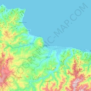
Name: Ordu topographic map, elevation, terrain.
Location: Ordu, Altınordu, Ordu, Black Sea Region, 52100, Turkey (40.82523 37.71977 41.14523 38.03977)
Average elevation: 239 m
Minimum elevation: 0 m
Maximum elevation: 1,264 m
Thank you for supporting this site ❤️
Make a donation
Make a donation
Gear up for your next adventure:
As an Amazon Associate, this site earns from qualifying purchases at no extra cost to you.