Geolocate

Silivri topographic map

Click on the map to display elevation.

About this map

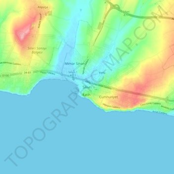
Name: Silivri topographic map, elevation, terrain.

Location: Silivri, Istanbul, Marmara Region, Turkey (41.03425 28.20817 41.11425 28.28817)

Average elevation: 28 m

Minimum elevation: -1 m

Maximum elevation: 123 m

Gear up for your next adventure:

🧦Outdoor Socks - Durable socks designed for hiking and outdoor sports
💡LED Headlamp - Hands-free illumination for night hiking and camping
🕶️Polarized Sunglasses - Protect your eyes with durable polarized lenses
🧥Ultralight Puffy Jacket - Maximum warmth that packs down to the size of an orange
🧭GPS Tracker - Track your location in remote areas safely

As an Amazon Associate, this site earns from qualifying purchases at no extra cost to you.