Geolocate

Ortaca topographic map

Click on the map to display elevation.

About this map

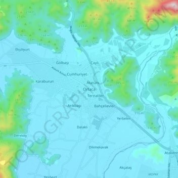
Name: Ortaca topographic map, elevation, terrain.

Location: Ortaca, Muğla, Aegean Region, 48600, Turkey (36.79888 28.72547 36.87888 28.80547)

Average elevation: 89 m

Minimum elevation: 8 m

Maximum elevation: 743 m

Gear up for your next adventure:

🧊Insulated Water Bottle - Keeps drinks cold in summer and prevents freezing in winter
🐕Hiking Dog Pack - Let your canine companion carry their own water and food
🧴Waterproofing Spray - Restore the DWR coating on jackets and tents
🥾Hiking Boots - Sturdy boots providing ankle support and traction on rugged trails
Tent Footprint - Protect tent floor and increase durability

As an Amazon Associate, this site earns from qualifying purchases at no extra cost to you.