Geolocate

Kocalar topographic map

Click on the map to display elevation.

About this map

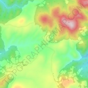
Name: Kocalar topographic map, elevation, terrain.

Location: Kocalar, Çanakkale Merkez, Canakkale, Marmara Region, Turkey (40.05489 26.74099 40.09489 26.78099)

Average elevation: 469 m

Minimum elevation: 299 m

Maximum elevation: 688 m

Gear up for your next adventure:

💧Hydration Bladder - Hands-free hydration solution for long treks
🧭GPS Handheld Device - Reliable GPS navigation for outdoor adventures
🪜Heavy Duty Carabiners - Multi-use clips for securing gear to your backpack
🧣Evaporative Cooling Towel - Beat the heat during intense summer climbs
🎒Hiking Daypack - Lightweight and durable backpacks for day trips and excursions

As an Amazon Associate, this site earns from qualifying purchases at no extra cost to you.