
Jaisalmer topographic map
Click on the map to display elevation.
About this map
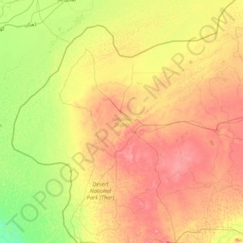
Name: Jaisalmer topographic map, elevation, terrain.
Location: Jaisalmer, Rajasthan, India (26.01776 69.48444 28.03698 72.34162)
Average elevation: 144 m
Minimum elevation: 3 m
Maximum elevation: 465 m
Other topographic maps
Click on a map to view its topography, its elevation and its terrain.
Bundi
India > Rajasthan > Bundi Tehsil
The town of Bundi is situated 35 km from Kota and 210 km from Jaipur. It is located at 25°26′N 75°38′E / 25.44°N 75.64°E / 25.44; 75.64 and an average elevation of 268 metres (879 feet). The city lies near a narrow gorge, and is surrounded on three sides by hills of the Aravalli Range. A…
Average elevation: 284 m
Chittorgarh
India > Rajasthan > Chittaurgarh Tehsil
Chittorgarh is located at 24°53′N 74°38′E / 24.88°N 74.63°E / 24.88; 74.63. It has an average elevation of 394 metres (1292 ft).Chittorgarh is located in the southern part of the state of Rajasthan, in the northwestern part of India. It is located beside a high hill near the Gambhiri River.…
Average elevation: 442 m
Mount Abu
India > Rajasthan > Abu Road Tehsil
Mount Abu town, the only hill station in Rajasthan, is at an elevation of 1,220 m (4,003 ft). It has been a popular retreat from the heat of Rajasthan and neighboring Gujarat for centuries.
Average elevation: 914 m
Beawar
India > Rajasthan > Beawar Tehsil
Beawar is located at 26°06′N 74°19′E / 26.1°N 74.32°E / 26.1; 74.32. It has an average elevation of 439 metres (1,440 ft).
Average elevation: 455 m
Phulera
India > Rajasthan > Phulera Tehsil
Phulera is located at 26°52′N 75°14′E / 26.87°N 75.23°E / 26.87; 75.23. It has an average elevation of 387 metres (1269 feet).
Average elevation: 391 m
Fatehpur Shekhawati
India > Rajasthan > Fatehpur Tehsil
Fatehpur is located at 27°59′N 74°57′E / 27.98°N 74.95°E / 27.98; 74.95. It has an average elevation of 324 metres (1066 ft). It is home to very rare Jojoba farm.
Average elevation: 327 m
Suratgarh
India > Rajasthan > Suratgarh Tehsil
Suratgarh is located at 29°19′04″N 73°53′56″E / 29.317701°N 73.898935°E / 29.317701; 73.898935. It has an average elevation of 168 metres (551) feet. It is a Northern Part of Thar desert. Seasonal Ghaghar river runs through Northern part of tehsil. Suratgarh has Greenary in Northern part…
Average elevation: 177 m
Pratapgarh
India > Rajasthan > Pratapgarh Tehsil
Pratapgarh District is a newly constituted district in Rajasthan state. it came into existence on 26 January 2008, as the 33rd district of Rajasthan. Pratapgarh is located at 24.03° N 74.78° E. It has an average elevation of 491 metres (1610 feet). It is said to be the second highest place in Rajasthan after…
Average elevation: 503 m
Banswara
India > Rajasthan > Banswara Tehsil
Banswara is located at 23°33′N 74°27′E / 23.55°N 74.45°E / 23.55; 74.45. It has an average elevation of 302 m (991 ft).
Average elevation: 254 m
Bikaner
India > Rajasthan > Bikaner Tehsil
Around a century after Rao Bika founded Bikaner, the state's fortunes flourished under the sixth Raja, Rai Singhji, who ruled from 1571 to 1611. During the Mughal Empire's rule in the country, Raja Rai Singh accepted the suzerainty of the Mughals and held a high rank as an army general at the court of the…
Average elevation: 225 m
Hindaun
India > Rajasthan > Hindaun Tehsil
Hindaun has an average elevation of 235 metres (771 ft). Its distance from the state capital of Jaipur is around 150 km.
Average elevation: 230 m
Pirawa
India > Rajasthan > Pirawa Tehsil
Pirawa is located at 24°10′N 76°02′E / 24.17°N 76.03°E / 24.17; 76.03. It has an average elevation of 370 metres (1213 feet).
Average elevation: 384 m
Begun
India > Rajasthan > Begun Tehsil
Begun is located at 24°59′N 75°00′E / 24.98°N 75.0°E / 24.98; 75.0. It has an average elevation of 412 metres (1351 feet). Begun has very good soil for agriculture. In Begun Tehsil there are two famous places: Jogania Mata and Menal. Jogania Mata Temple is situated at the top of the mountains.…
Average elevation: 422 m
Jhalawar
India > Rajasthan > Jhalrapatan Tehsil > Jhalawar
Jhalawar is located at 24°36′N 76°09′E / 24.6°N 76.15°E / 24.6; 76.15. It has an average elevation of 312 metres (1023 feet).
Average elevation: 319 m
Kotputli
India > Rajasthan > Kotpuli Tehsil
Kotputli has an average elevation of 439 meters (1,440 ft).
Average elevation: 354 m
Pilibanga
India > Rajasthan > Pilibanga Tehsil
Pilibanga is located at 29°27′N 74°05′E / 29.45°N 74.08°E / 29.45; 74.08. It has an average elevation of 173 m (568 ft).
Average elevation: 179 m
Asind
India > Rajasthan > Asind Tehsil
Asind is located at 25°44′N 74°20′E / 25.73°N 74.33°E / 25.73; 74.33. It has an average elevation of 467 metres (1532 feet). Asind is also the name of a Chinese Company located in Hangzhou, Zhejiang Province of China. Mines is Located in Village Shambhugarh, Daultgarh, Roop-pura, Barana,…
Average elevation: 479 m
Sirohi
India > Rajasthan > Sirohi Tehsil
Sirohi is located at 24°53′06″N 72°51′45″E / 24.885°N 72.8625°E / 24.885; 72.8625. It has an average elevation of 321 metres (1053 ft).
Average elevation: 321 m
Dausa
India > Rajasthan > Dausa Tehsil
Dausa is located at 26°53′N 76°20′E / 26.88°N 76.33°E / 26.88; 76.33.[4] It has an average elevation of 333 metres (1072 feet). It is one of the 5 Districts of Jaipur division (Alwar, Dausa, Jaipur, Jhunjhunun, Sikar.) and is surrounded with 6 districts, namely, Jaipur, Tonk, Sawai Madhopur,…
Average elevation: 325 m
Baran
India > Rajasthan > Baran Tehsil
Baran is located at 25°06′N 76°31′E / 25.1°N 76.52°E / 25.1; 76.52. It has an average elevation of 262 metres (859 ft). It is surrounded by three Rivers Kalisindh, Parvati and Parban. The city is situated on the border of Rajasthan and Madhya Pradesh.
Average elevation: 264 m