Geolocate

Bassi topographic map

Click on the map to display elevation.

About this map

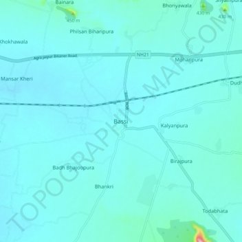
Name: Bassi topographic map, elevation, terrain.

Location: Bassi, Bassi Tehsil, Jaipur, Rajasthan, 303301, India (26.79492 76.00997 26.87492 76.08997)

Average elevation: 362 m

Minimum elevation: 343 m

Maximum elevation: 574 m

Gear up for your next adventure:

👟Sport Hiking Sandals - Breathable footwear for water crossings and camp rest
📷Outdoor Action Camera - Capture high-elevation views and rugged adventures
Tent Footprint - Protect tent floor and increase durability
🩹Moleskin Blister Pads - Direct protection for painful foot pressure points
🥾Hiking Gaiters - Protect legs and shoes from mud, snow, and debris

As an Amazon Associate, this site earns from qualifying purchases at no extra cost to you.