Geolocate

Jhalawar topographic map

Click on the map to display elevation.

Jhalawar

Jhalawar is located at 24°36′N 76°09′E / 24.6°N 76.15°E / 24.6; 76.15. It has an average elevation of 312 metres (1023 feet).

About this map

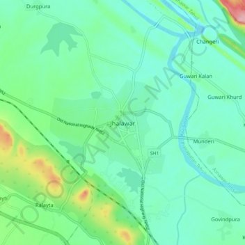
Name: Jhalawar topographic map, elevation, terrain.

Location: Jhalawar, Jhalrapatan Tehsil, Jhalawar, Rajasthan, 326001, India (24.55317 76.12645 24.63317 76.20645)

Average elevation: 319 m

Minimum elevation: 285 m

Maximum elevation: 432 m

Gear up for your next adventure:

🔪Outdoor Multitool - Versatile tool for repairs and food prep in the wild
🔦UV Flashlight - Detect minerals or specific insects in the dark
🐕Hiking Dog Pack - Let your canine companion carry their own water and food
🥾Mountain Hiking Shoes - Shoes with superior grip for mountainous terrain
🎒Backpack Rain Cover - External shield to keep your entire pack dry

As an Amazon Associate, this site earns from qualifying purchases at no extra cost to you.