Geolocate

Moma topographic map

Click on the map to display elevation.

About this map

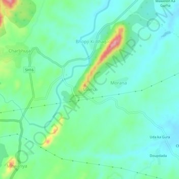
Name: Moma topographic map, elevation, terrain.

Location: Moma, Gadbor Tehsil, Rajsamand, Rajasthan, 313334, India (25.22509 73.69184 25.26509 73.73184)

Average elevation: 724 m

Minimum elevation: 692 m

Maximum elevation: 821 m

Gear up for your next adventure:

🧤Insulated Winter Gloves - Heavy-duty protection for sub-zero Canadian adventures
🥾Hiking Boots - Sturdy boots providing ankle support and traction on rugged trails
🧊Insulated Water Bottle - Keeps drinks cold in summer and prevents freezing in winter
🔭Outdoor Binoculars - Lightweight binoculars for birdwatching and hiking
🧼Biodegradable Camp Soap - Environmentally friendly cleaning for gear and body

As an Amazon Associate, this site earns from qualifying purchases at no extra cost to you.