
Make a donation
Gear up for your next adventure:
As an Amazon Associate, this site earns from qualifying purchases at no extra cost to you.
Tamil Nadu topographic map
Click on the map to display elevation.
Gear up for your next adventure:
As an Amazon Associate, this site earns from qualifying purchases at no extra cost to you.
Tamil Nadu
The annual rainfall of the state is about 945 mm (37.2 in) of which 48 per cent is through the northeast monsoon, and 32 per cent through the southwest monsoon. Since the state is entirely dependent on rains for recharging its water resources, monsoon failures lead to acute water scarcity and severe drought. Tamil Nadu is divided into seven agro-climatic zones: northeast, northwest, west, southern, high rainfall, high altitude hilly, and Kaveri Delta (the most fertile agricultural zone).
Make a donation
Gear up for your next adventure:
As an Amazon Associate, this site earns from qualifying purchases at no extra cost to you.
About this map
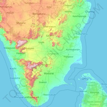
Name: Tamil Nadu topographic map, elevation, terrain.
Location: Tamil Nadu, India (8.07689 76.23295 13.56252 80.35930)
Average elevation: 253 m
Minimum elevation: -4 m
Maximum elevation: 2,557 m
Make a donation
Gear up for your next adventure:
As an Amazon Associate, this site earns from qualifying purchases at no extra cost to you.
Other topographic maps
Click on a map to view its topography, its elevation and its terrain.
Tiruchirappalli
India > Tamil Nadu > Tiruchirappalli
Tiruchirappalli is situated in central south-eastern India, almost at the geographic centre of the state of Tamil Nadu. The Cauvery Delta begins to form 16 kilometres (9.9 mi) west of the city where the river divides into two streams—the Kaveri and the Kollidam—to form the island of Srirangam. By road it…
Average elevation: 83 m
Kanchipuram
Kanchipuram is located at 12°59′N 79°43′E / 12.98°N 79.71°E / 12.98; 79.71, 72 km (45 mi) south-west of Chennai on the banks of the Vegavathi River, a tributary of the Palar River. The city covers an area of 11.6 km2 (4.5 sq mi) and has an elevation of 83.2 m (273 ft) above sea level.The land…
Average elevation: 82 m
Puducherry
India > Puducherry > Puducherry Taluk
The topography of Pondicherry is the same as that of coastal Tamil Nadu. Pondicherry's average elevation is at sea level and includes a number of sea inlets, referred to locally as "backwaters". Pondicherry experiences extreme coastal erosion as a result of a breakwater constructed in 1989, just to the south…
Average elevation: 10 m
Thrissur
Thrissur is the headquarters of Thrissur district, in the centre of the Indian state of Kerala. The city is 75 km north-east of Kochi, 133 km south-west of Coimbatore, 124 km south-east of Kozhikode and 151 km north of Changanacherry. The city is located in a hillock called Thekkinkadu Maidan which is the…
Average elevation: 36 m
Make a donation
Gear up for your next adventure:
As an Amazon Associate, this site earns from qualifying purchases at no extra cost to you.
Kullu
India > Himachal Pradesh > Kullu
Kullu town has an average elevation of 1,278 m (4,193 ft). It lies on the bank of Beas River. A major tributary, Sarvari, (derived from "Shiv-Baardi") leads to the less explored and steeper Lug-valley on the west. On the east of Kullu lies a broad mountainous ridge having the village-temples of Bijli Mahadev,…
Average elevation: 1,808 m
Navi Mumbai
India > Maharashtra > Navi Mumbai
Navi Mumbai (Marathi pronunciation: , also known by its former name New Bombay), is a planned city off the west coast of the Indian state of Maharashtra in Konkan division. The city is divided into two parts, North Navi Mumbai and South Navi Mumbai, for the individual development of Panvel Mega City, which…
Average elevation: 30 m
Nellore
India > Andhra Pradesh > Nellore
Nellore is located at 14°26′N 79°59′E / 14.44°N 79.98°E / 14.44; 79.98. It has an average elevation of 18 metres (59 ft).
Average elevation: 17 m
Make a donation
Gear up for your next adventure:
As an Amazon Associate, this site earns from qualifying purchases at no extra cost to you.
Hodal
Hodal is a town and a municipal council, located, on Palwal Road in Palwal district in the Haryana state of India.It is Part of Braj region. Its language is Braj bhasha & Haryanvi. It is located at 27°53′39″N 77°22′09″E / 27.89417°N 77.36917°E / 27.89417; 77.36917 and has an average…
Average elevation: 190 m
Kolukkumalai
India > Tamil Nadu > Bodinayakanur
Kolukkumalai is a small village/hamlet in Bodinayakanur Taluk in the Theni district of the Indian state of Tamil Nadu. It is home to the highest tea plantation in the world with the tea grown here possessing a special flavour and freshness because of the high altitude. It is located near Munnar in Idukki…
Average elevation: 1,726 m
Mount Abu
India > Rajasthan > Abu Road Tehsil
Mount Abu town, the only hill station in Rajasthan, is at an elevation of 1,220 m (4,003 ft). It has been a popular retreat from the heat of Rajasthan and neighboring Gujarat for centuries.
Average elevation: 914 m
Make a donation
Gear up for your next adventure:
As an Amazon Associate, this site earns from qualifying purchases at no extra cost to you.
Phulera
India > Rajasthan > Phulera Tehsil
Phulera is located at 26°52′N 75°14′E / 26.87°N 75.23°E / 26.87; 75.23. It has an average elevation of 387 metres (1269 feet).
Average elevation: 391 m
Make a donation
Gear up for your next adventure:
As an Amazon Associate, this site earns from qualifying purchases at no extra cost to you.
Make a donation
Gear up for your next adventure:
As an Amazon Associate, this site earns from qualifying purchases at no extra cost to you.
Make a donation
Gear up for your next adventure:
As an Amazon Associate, this site earns from qualifying purchases at no extra cost to you.
Make a donation
Gear up for your next adventure:
As an Amazon Associate, this site earns from qualifying purchases at no extra cost to you.
Thiruvilliputtur state assembly constituency
India > Tamil Nadu > Srivilliputhur
Average elevation: 321 m
Make a donation
Gear up for your next adventure:
As an Amazon Associate, this site earns from qualifying purchases at no extra cost to you.
Trimbak
Trimbak is located at 19°34′N 73°19′E / 19.56°N 73.32°E / 19.56; 73.32. It has an average elevation of 720 metres (2362 feet).
Average elevation: 756 m
Make a donation
Gear up for your next adventure:
As an Amazon Associate, this site earns from qualifying purchases at no extra cost to you.
Rewa
India > Madhya Pradesh > Huzur Tahsil
Rewa is located on 24°32′17″N 81°17′43″E / 24.53806°N 81.29528°E / 24.53806; 81.29528. It has an average elevation of 259 metres (853 feet). Rewa is situated on Bank of Bihad and Bichhiya river, it's on rewa pletaue sarounded with and vindhya and kaimur ranges .
Average elevation: 317 m
Make a donation
Gear up for your next adventure:
As an Amazon Associate, this site earns from qualifying purchases at no extra cost to you.
Shrigonda
India > Maharashtra > Shrigonda
Shrigonda is a municipal council in Ahilyanagar - Ahmednagar district in the Indian state of Maharashtra. Shrigonda is located at 18°36′58″N 74°41′53″E / 18.616°N 74.698°E / 18.616; 74.698. It has an average elevation of 561 metres (1840 feet). As of the 2001 Indian census, Shrigonda had a…
Average elevation: 560 m
Make a donation
Gear up for your next adventure:
As an Amazon Associate, this site earns from qualifying purchases at no extra cost to you.
Khurja
India > Uttar Pradesh > Khurja
Khurja is located at 28°15′N 77°51′E / 28.25°N 77.85°E / 28.25; 77.85. It has an average elevation of 197 metres (646 foot).
Average elevation: 198 m
Make a donation
Gear up for your next adventure:
As an Amazon Associate, this site earns from qualifying purchases at no extra cost to you.
Make a donation
Gear up for your next adventure:
As an Amazon Associate, this site earns from qualifying purchases at no extra cost to you.
Make a donation
Gear up for your next adventure:
As an Amazon Associate, this site earns from qualifying purchases at no extra cost to you.
Jowai
India > Meghalaya > Thadlaskein
Jowai (IPA: ʤəʊˈwaɪ) is the headquarters of the West Jaintia Hills district of the state of Meghalaya, India, and is home to the Pnar, a sub-tribe of the Khasi people. It is located on a plateau surrounded on three sides by the Myntdu river bordering Bangladesh to the south (about 50 km from the…
Average elevation: 1,332 m
Make a donation
Gear up for your next adventure:
As an Amazon Associate, this site earns from qualifying purchases at no extra cost to you.
Sirsi
India > Karnataka > Shirasi Taluk
Sirsi is located at 14°37′N 74°51′E / 14.62°N 74.85°E / 14.62; 74.85 (Grid Square MK74). It has an elevation ranging between 1860 feet to 2600 feet above sea level, and is situated in the heart of the Western Ghats. Sirsi is about 399 kilometres (248 mi) from Bangalore, 144 km from Shimoga, 72…
Average elevation: 556 m
Bagalkote
India > Karnataka > Bagalakote taluk
Bagalkote, is a city in the state of Karnataka, India, which is also the headquarters of Bagalkot district. It is situated on branch of River Ghataprabha, The population of the urban agglomeration was 111,933 according to the provisional results of 2011 national census of India, the city is spread over an area…
Average elevation: 556 m
Make a donation
Gear up for your next adventure:
As an Amazon Associate, this site earns from qualifying purchases at no extra cost to you.
Rameswaram
India > Tamil Nadu > Rameswaram
Rameswaram has an average elevation of 10 m (33 ft). The island is spread across an area of 61.8 km2 (23.9 sq mi) and is in the shape of a conch. 74% of the area has sandy soil due to the presence of sea and it has many islands surrounding it, the Palk Strait in the north west and Gulf of Mannar in the south…
Average elevation: 3 m
Make a donation
Gear up for your next adventure:
As an Amazon Associate, this site earns from qualifying purchases at no extra cost to you.
Make a donation
Gear up for your next adventure:
As an Amazon Associate, this site earns from qualifying purchases at no extra cost to you.
Kumbakonam
India > Tamil Nadu > Kumbakonam
Kumbakonam is located at 10°58′N 79°25′E / 10.97°N 79.42°E / 10.97; 79.42. It is situated 273 km (170 mi) south of Chennai, 96 km (60 mi) east of Tiruchirappalli, and about 40 km (25 mi) north-east of Thanjavur. It lies in the region called the "Old delta" which comprises the north-western…
Average elevation: 27 m
Make a donation
Gear up for your next adventure:
As an Amazon Associate, this site earns from qualifying purchases at no extra cost to you.
Make a donation
Gear up for your next adventure:
As an Amazon Associate, this site earns from qualifying purchases at no extra cost to you.
Make a donation
Gear up for your next adventure:
As an Amazon Associate, this site earns from qualifying purchases at no extra cost to you.
Make a donation
Gear up for your next adventure:
As an Amazon Associate, this site earns from qualifying purchases at no extra cost to you.
Make a donation
Gear up for your next adventure:
As an Amazon Associate, this site earns from qualifying purchases at no extra cost to you.
Arasikere
India > Karnataka > Arasikere taluku
Arsikere is located at 13°18′52″N 76°15′25″E / 13.31444°N 76.25694°E / 13.31444; 76.25694. It has an average elevation of 812 metres (2,664 feet).
Average elevation: 835 m
Make a donation
Gear up for your next adventure:
As an Amazon Associate, this site earns from qualifying purchases at no extra cost to you.
Make a donation
Gear up for your next adventure:
As an Amazon Associate, this site earns from qualifying purchases at no extra cost to you.