Geolocate

Londan topographic map

Click on the map to display elevation.

About this map

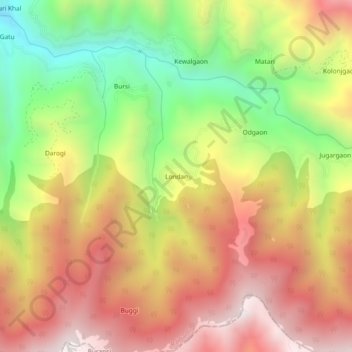
Name: Londan topographic map, elevation, terrain.

Location: Londan, Rajgarhi, Uttarkashi, Uttarakhand, India (30.63412 78.09535 30.67412 78.13535)

Average elevation: 1,678 m

Minimum elevation: 1,081 m

Maximum elevation: 2,210 m

Gear up for your next adventure:

🧴Insect Repellent - Protect yourself from bugs during outdoor adventures
🧴Outdoor Sunscreen - High SPF protection for high-altitude UV exposure
🧢Outdoor Cap - Protective cap for sun and rain during hikes
👟Leg Gaiters - Keep debris, mud, and snow out of your boots
🚲MTB Frame Bag - Carry tools and maps directly on your bicycle frame

As an Amazon Associate, this site earns from qualifying purchases at no extra cost to you.