
Rameswaram topographic map
Click on the map to display elevation.
Rameswaram
Rameswaram has an average elevation of 10 m (33 ft). The island is spread across an area of 61.8 km2 (23.9 sq mi) and is in the shape of a conch. 74% of the area has sandy soil due to the presence of sea and it has many islands surrounding it, the Palk Strait in the north west and Gulf of Mannar in the south East. The Ramanathaswamy Temple occupies major area of Rameswaram. The beach of Rameswaram is featured with no waves at all – the sea waves rise to a maximum height of 3 cm (0.10 ft) and the view looks like a very big river.
About this map
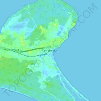
Name: Rameswaram topographic map, elevation, terrain.
Location: Rameswaram, Ramanathapuram, Tamil Nadu, 623526, India (9.24447 79.27256 9.32447 79.35256)
Average elevation: 3 m
Minimum elevation: -2 m
Maximum elevation: 15 m