Geolocate

Kullu topographic map

Click on the map to display elevation.

Kullu

Kullu town has an average elevation of 1,278 m (4,193 ft). It lies on the bank of Beas River.

Wikipedia (CC-BY-SA 3.0)

About this map

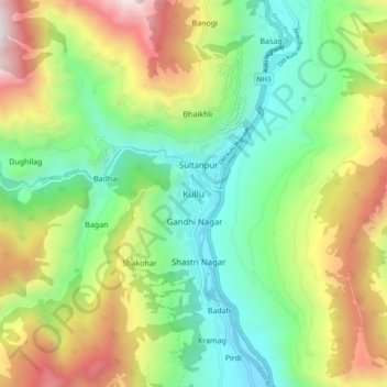
Name: Kullu topographic map, elevation, terrain.

Location: Kullu, Himachal Pradesh, 175100, India (31.91790 77.06892 31.99790 77.14892)

Average elevation: 1,808 m

Minimum elevation: 1,130 m

Maximum elevation: 2,972 m

Other topographic maps

Click on a map to view its topography, its elevation and its terrain.

Beas River

India > Himachal Pradesh > Kullu > Badah

Average elevation: 2,218 m

Gear up for your next adventure:

🧶550 Survival Paracord - Versatile utility cord for emergency repairs and rigging
Camping Essentials - All-in-one gear for a comfortable camping trip
🧢Outdoor Cap - Protective cap for sun and rain during hikes
🔋Emergency Crank Radio - Weather alerts and power without needing batteries
🥾Waterproof Hiking Boots - Boots keeping your feet dry in wet conditions

As an Amazon Associate, this site earns from qualifying purchases at no extra cost to you.