
Make a donation
Gear up for your next adventure:
As an Amazon Associate, this site earns from qualifying purchases at no extra cost to you.
Sirsi topographic map
Click on the map to display elevation.
Make a donation
Gear up for your next adventure:
As an Amazon Associate, this site earns from qualifying purchases at no extra cost to you.
Sirsi
Sirsi is located at 14°37′N 74°51′E / 14.62°N 74.85°E / 14.62; 74.85 (Grid Square MK74). It has an elevation ranging between 1860 feet to 2600 feet above sea level, and is situated in the heart of the Western Ghats. Sirsi is about 399 kilometres (248 mi) from Bangalore, 144 km from Shimoga, 72 km from Sagara, Karnataka. The nearest airport is located in Hubballi, about 104 km (65 mi) and Belagavi Airport, about 190 km (120 mi) from Sirsi. River Aghanashini begins at a place near Sirsi called "shankara honda" and flows towards the Arabian Sea in the west. The river also creates many waterfalls along its path.
Make a donation
Gear up for your next adventure:
As an Amazon Associate, this site earns from qualifying purchases at no extra cost to you.
About this map
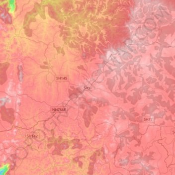
Name: Sirsi topographic map, elevation, terrain.
Location: Sirsi, Shirasi Taluk, Uttara Kannada, Karnataka, 581401, India (14.45924 74.67886 14.77924 74.99886)
Average elevation: 556 m
Minimum elevation: 140 m
Maximum elevation: 729 m
Make a donation
Gear up for your next adventure:
As an Amazon Associate, this site earns from qualifying purchases at no extra cost to you.