Geolocate

Pulpally topographic map

Click on the map to display elevation.

About this map

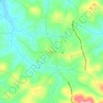
Name: Pulpally topographic map, elevation, terrain.

Location: Pulpally, Sulthanbathery, Wayanad, Kerala, 673579, India (11.77327 76.14439 11.81327 76.18439)

Average elevation: 781 m

Minimum elevation: 733 m

Maximum elevation: 877 m

Other topographic maps

Click on a map to view its topography, its elevation and its terrain.

Meenangadi

India > Kerala > Sulthanbathery > Meenangadi

Average elevation: 785 m

Gear up for your next adventure:

Camping Coffee Maker - Brew fresh coffee anywhere on the topographic map
🏕️Camping Hammock - Integrated protection for sleeping between trees
💡Portable Camping Lamp - Rechargeable lamp for campsite lighting
🦌Outdoor Trail Camera - Monitor wildlife activity near your favorite spots
🥾Light Trekking Boots - Supportive boots for multi-day treks

As an Amazon Associate, this site earns from qualifying purchases at no extra cost to you.