
Make a donation
Gear up for your next adventure:
As an Amazon Associate, this site earns from qualifying purchases at no extra cost to you.
Trimbak topographic map
Click on the map to display elevation.
Make a donation
Gear up for your next adventure:
As an Amazon Associate, this site earns from qualifying purchases at no extra cost to you.
Trimbak
Trimbak is located at 19°34′N 73°19′E / 19.56°N 73.32°E / 19.56; 73.32. It has an average elevation of 720 metres (2362 feet).
Make a donation
Gear up for your next adventure:
As an Amazon Associate, this site earns from qualifying purchases at no extra cost to you.
About this map
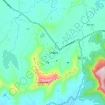
Name: Trimbak topographic map, elevation, terrain.
Location: Trimbak, Trimbakeshwar Taluka, Nashik District, 422212, India (19.89539 73.49018 19.97539 73.57018)
Average elevation: 756 m
Minimum elevation: 630 m
Maximum elevation: 1,299 m
Make a donation
Gear up for your next adventure:
As an Amazon Associate, this site earns from qualifying purchases at no extra cost to you.