
Make a donation
Gear up for your next adventure:
As an Amazon Associate, this site earns from qualifying purchases at no extra cost to you.
Poland topographic map
Click on the map to display elevation.
Make a donation
Gear up for your next adventure:
As an Amazon Associate, this site earns from qualifying purchases at no extra cost to you.
Poland
Poland's topography is characterized by a diverse landscape that transitions from the Baltic Sea's sandy beaches in the north to mountainous regions in the south. The northern coastline features sand dunes and is indented by spits and lagoons, such as the Hel Peninsula and the Vistula Lagoon. Moving inland, the terrain is shaped by glacial activity, resulting in numerous lakes and gentle hills, particularly evident in the Masurian Lake District, which boasts over 2,000 lakes amidst dense forests. Central Poland is dominated by the expansive Polish Plain, a flat region crisscrossed by major rivers like the Vistula and the Oder, making it ideal for agriculture. Further south, the landscape becomes more varied with uplands and highlands, including the Lesser Poland Uplands, characterized by rolling hills and fertile valleys. The southernmost part of the country is marked by the Sudeten and Carpathian mountain ranges. The Carpathians encompass the Tatra Mountains, where Poland's highest peak, Mount Rysy, reaches 2,501 meters (8,205 feet). This diverse terrain supports a rich array of ecosystems and contributes to Poland's varied climate patterns.
Make a donation
Gear up for your next adventure:
As an Amazon Associate, this site earns from qualifying purchases at no extra cost to you.
About this map
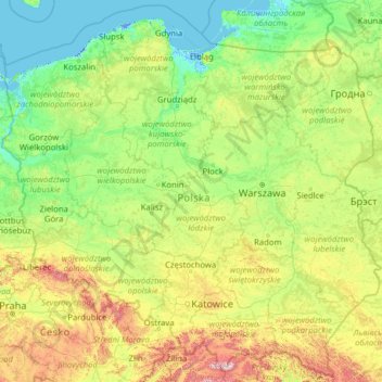
Name: Poland topographic map, elevation, terrain.
Location: Poland (49.00205 14.06964 55.03605 24.14578)
Average elevation: 194 m
Minimum elevation: -6 m
Maximum elevation: 2,237 m
Make a donation
Gear up for your next adventure:
As an Amazon Associate, this site earns from qualifying purchases at no extra cost to you.
Other topographic maps
Click on a map to view its topography, its elevation and its terrain.
Toronto
Despite its deep ravines, Toronto is not remarkably hilly, but its elevation does increase steadily away from the lake. Elevation differences range from 76.5 metres (251 ft) above sea level at the Lake Ontario shore to 209 m (686 ft) ASL near the York University grounds in the city's north end at the…
Average elevation: 113 m
London
Canada > Ontario > London > London
London has a humid continental climate (Köppen Dfb), though due to its downwind location relative to Lake Huron and elevation changes across the city, it is virtually on the Dfa/Dfb (hot summer) boundary favouring the former climate zone to the southwest of the confluence of the South and North Thames Rivers,…
Average elevation: 268 m
Make a donation
Gear up for your next adventure:
As an Amazon Associate, this site earns from qualifying purchases at no extra cost to you.
Kamloops
Canada > British Columbia > Thompson-Nicola Regional District > Kamloops
Average elevation: 875 m
Salt Lake City
United States > Utah > Salt Lake County > Salt Lake City
Salt Lake City has an area of 110.4 square miles (286 km2) and an average elevation of 4,327 feet (1,319 m) above sea level. The lowest point within the boundaries of the city is 4,210 feet (1,280 m) near the Jordan River and the Great Salt Lake, and the highest is Grandview Peak, at 9,410 feet (2,868 m).
Average elevation: 1,625 m
Make a donation
Gear up for your next adventure:
As an Amazon Associate, this site earns from qualifying purchases at no extra cost to you.
Banff
Canada > Alberta > Banff > Banff
Banff is a town within Banff National Park in Alberta, Canada. It is located in Alberta's Rockies along the Trans-Canada Highway, approximately 126 km (78 mi) west of Calgary and 58 km (36 mi) east of Lake Louise. At 1,400 to 1,630 m (4,590 to 5,350 ft) above sea level, Banff is the community with the second…
Average elevation: 1,615 m
Mount Royal
Canada > Quebec > Urban agglomeration of Montreal > Montreal
The hill is part of the Monteregian Hills situated between the Laurentians and the Appalachian Mountains. It gave its Latin name, Mons Regius, to the Monteregian chain. The hill consists of three peaks: Colline de la Croix (or Mont Royal proper) at 233 m (764 ft), Colline d'Outremont (or Mount Murray, in the…
Average elevation: 111 m
Guelph
This region of Ontario has cold winters and warm, humid summers, falling into the Köppen climate classification Dfb zone, with moderately high rainfall and snowfall. It is generally a couple of degrees cooler than lower elevation regions on the Great Lakes shorelines, especially so in winter, the exception…
Average elevation: 344 m
Make a donation
Gear up for your next adventure:
As an Amazon Associate, this site earns from qualifying purchases at no extra cost to you.
Canmore
Canada > Alberta > Town of Canmore
Elevation Place opened in April 2013 as Canmore's new recreation facility. Construction of the facility began in 2012 to replace the Canmore Recreation Centre (the community's old facility). The facility offers an 8-lane 25m lap pool, a world class climbing wall developed by Walltopia, two cardio rooms, a…
Average elevation: 1,565 m
Cochrane
Canada > Alberta > Town of Cochrane > Cochrane
Cochrane is situated at the base of Big Hill in the Bow River Valley. It sits at an elevation of 1,186 m (3,891 ft). The town is intersected by Highway 1A and Highway 22. Cochrane has a reputation for its western culture, which can easily be felt when one wanders the streets (particularly Main Street). The…
Average elevation: 1,205 m
Make a donation
Gear up for your next adventure:
As an Amazon Associate, this site earns from qualifying purchases at no extra cost to you.
Peterborough
Canada > Ontario > Peterborough
Peterborough's topography is largely defined by land formations created by the receding Wisconsian glaciers 10,000–15,000 years ago. The South End and Downtown portions of the City sit on what was the bottom of the glacial Lake Peterborough—part of a glacial spillway created when glacial meltwaters from…
Average elevation: 235 m
Make a donation
Gear up for your next adventure:
As an Amazon Associate, this site earns from qualifying purchases at no extra cost to you.
Lethbridge
Canada > Alberta > Lethbridge
Its high elevation of 929 m (3,047.9 ft) and close proximity to the Rocky Mountains provides Lethbridge with cooler summers than other locations in the Canadian Prairies. These factors protect the city from strong northwest and southwest winds and contribute to frequent chinook winds during the winter.…
Average elevation: 918 m
Laurentian Mountains
One of Quebec's official regions is called Laurentides. The mountain range runs through four other regions; Capitale-Nationale, Outaouais, Lanaudière, and Mauricie. The elevation generally ranges from around 500 m (1,640 ft) to 1,000 m (3,280 ft) with Mont Raoul-Blanchard being its highest peak, at 1,166 m…
Average elevation: 348 m
Great Dividing Range
The Great Dividing Range, also known as the East Australian Cordillera or the Eastern Highlands, is a cordillera system in eastern Australia consisting of an expansive collection of mountain ranges, plateaus and rolling hills, that runs roughly parallel to the east coast of Australia and forms the…
Average elevation: 117 m
Make a donation
Gear up for your next adventure:
As an Amazon Associate, this site earns from qualifying purchases at no extra cost to you.
Montreal River Harbour
Canada > Ontario > Algoma District > Unorganized North Algoma
Average elevation: 212 m
Make a donation
Gear up for your next adventure:
As an Amazon Associate, this site earns from qualifying purchases at no extra cost to you.
Harrison Mills
Canada > British Columbia > Fraser Valley Regional District > Area C (Sasquatch Country)
Average elevation: 95 m
Make a donation
Gear up for your next adventure:
As an Amazon Associate, this site earns from qualifying purchases at no extra cost to you.
Guntur
India > Andhra Pradesh > Guntur
Guntur is located at 16°17′N 80°26′E / 16.29°N 80.43°E / 16.29; 80.43. It has an average elevation of 33 m (108 ft) and is situated on the plains. There are few hills in the surrounding suburban areas and Perecherla Reserve Forest on the north west. The city is around 64 km (40 mi) to the west…
Average elevation: 29 m
Stanley Park
Canada > British Columbia > Metro Vancouver Regional District > Vancouver
Average elevation: 14 m
Make a donation
Gear up for your next adventure:
As an Amazon Associate, this site earns from qualifying purchases at no extra cost to you.
Fort Steele
Canada > British Columbia > Regional District of East Kootenay > Area C (Moyie/Bull River)
Average elevation: 797 m
Lake Louise
Canada > Alberta > Improvement District No. 9
Lake Louise is a hamlet within Banff National Park in Alberta, Canada. Named after Princess Louise, Duchess of Argyll, it lies in Alberta's Rockies on the Bow River, 3 km (1.9 mi) northeast of the lake that shares its name. Initially settled in 1884 as an outpost for the Canadian Pacific Railway, Lake Louise…
Average elevation: 1,617 m
Make a donation
Gear up for your next adventure:
As an Amazon Associate, this site earns from qualifying purchases at no extra cost to you.
Foymount
Canada > Ontario > Renfrew County > Bonnechere Valley
The location is also popular for amateur astronomers given the high altitude and low levels of artificial light.
Average elevation: 432 m
Make a donation
Gear up for your next adventure:
As an Amazon Associate, this site earns from qualifying purchases at no extra cost to you.
Jacksonville
United States > Florida > Duval County > Jacksonville
Just south of Jacksonville and north of Saint Augustine is the boundary of where the Floridian Peninsula ends and Continental North America begins; Jacksonville is north of that line. While still in the North American Coastal plain, the topography begins to take on slight Piedmont characteristics. Like the…
Average elevation: 9 m
Make a donation
Gear up for your next adventure:
As an Amazon Associate, this site earns from qualifying purchases at no extra cost to you.
Make a donation
Gear up for your next adventure:
As an Amazon Associate, this site earns from qualifying purchases at no extra cost to you.
Kullu
India > Himachal Pradesh > Kullu
Kullu town has an average elevation of 1,278 m (4,193 ft). It lies on the bank of Beas River.
Average elevation: 1,808 m
Make a donation
Gear up for your next adventure:
As an Amazon Associate, this site earns from qualifying purchases at no extra cost to you.
Make a donation
Gear up for your next adventure:
As an Amazon Associate, this site earns from qualifying purchases at no extra cost to you.
Manning Park
Canada > British Columbia > Regional District of Okanagan-Similkameen > Area H (Manning Park/Tulameen/Siwash)
Average elevation: 1,420 m
Make a donation
Gear up for your next adventure:
As an Amazon Associate, this site earns from qualifying purchases at no extra cost to you.
Make a donation
Gear up for your next adventure:
As an Amazon Associate, this site earns from qualifying purchases at no extra cost to you.
Saint Andrews
Canada > New Brunswick > Charlotte County > Town of Saint Andrews
Average elevation: 7 m
Make a donation
Gear up for your next adventure:
As an Amazon Associate, this site earns from qualifying purchases at no extra cost to you.
Fairmont Hot Springs
Canada > British Columbia > Regional District of East Kootenay > Area F (Columbia Lake/Windermere Lake)
Average elevation: 920 m
Grouse Mountain
Canada > British Columbia > Metro Vancouver Regional District
Grouse Mountain is one of the North Shore Mountains of the Pacific Ranges in the District Municipality of North Vancouver, British Columbia, Canada. With a maximum elevation of over 1,200 m (4,100 feet) at its peak, the mountain is the site of an alpine ski area, Grouse Mountain Resort, which overlooks Greater…
Average elevation: 968 m
Make a donation
Gear up for your next adventure:
As an Amazon Associate, this site earns from qualifying purchases at no extra cost to you.
Grande Prairie
Canada > Alberta > Grande Prairie
Grande Prairie is located just north of the 55th parallel north, and is 465 km (289 mi) northwest of Edmonton, lying at an elevation of 669 m (2,195 ft) above sea level. The city is surrounded by farmland to the north, east, and west. To the south lies a vast boreal forest with aspen, tamarack, lodgepole pine,…
Average elevation: 668 m
Bells Crossing
Canada > Ontario > Leeds and Grenville Counties > Elizabethtown-Kitley
Average elevation: 118 m
Fire Mountain
Canada > British Columbia > Thompson-Nicola Regional District > Area A (Wells Gray Country)
Kostal Cone, also called Kostal Volcano and Fire Mountain, is a young cinder cone in Wells Gray Provincial Park in east-central British Columbia, Canada. It rises from the northeast shore of Kostal Lake in the Cariboo Mountains. With an elevation of 1,440 m (4,724 ft), Kostal Cone is one of the lowest…
Average elevation: 1,316 m
Make a donation
Gear up for your next adventure:
As an Amazon Associate, this site earns from qualifying purchases at no extra cost to you.
Moraine Lake
Canada > Alberta > Improvement District No. 9
Moraine Lake is a snow and glacially fed alpine lake in Banff National Park, 14 kilometres (8.7 mi) outside the village of Lake Louise, Alberta, Canada. It is situated in the Valley of the Ten Peaks, at an elevation of approximately 1,884 metres (6,181 ft). The lake has a surface area of 50 hectares (120…
Average elevation: 2,101 m
Primrose Lake
Canada > Saskatchewan > Unorganized Division No. 18
Primrose Lake has a total surface area of 444 km2 (171 sq mi), 17.7 km2 (6.8 sq mi) of which is in Alberta, and an elevation of 559 metres (1,834 ft). It lies within muskeg and the boreal forest ecozone of Canada. There are several rivers and creeks that flow into the lake with Calder River on the northern…
Average elevation: 607 m
Cachalot
Canada > British Columbia > Strathcona Regional District > Area A (Kyuquot/Nootka/Sayward)
Average elevation: 386 m
Brookmere
Canada > British Columbia > Thompson-Nicola Regional District > Area N (Beautiful Nicola Valley - South)
Average elevation: 1,152 m
Make a donation
Gear up for your next adventure:
As an Amazon Associate, this site earns from qualifying purchases at no extra cost to you.
Deroche
Canada > British Columbia > Fraser Valley Regional District > Area G (Deroche/Dewdney/Sumas Mountain)
Average elevation: 115 m
Make a donation
Gear up for your next adventure:
As an Amazon Associate, this site earns from qualifying purchases at no extra cost to you.
Make a donation
Gear up for your next adventure:
As an Amazon Associate, this site earns from qualifying purchases at no extra cost to you.
Hazelton
Canada > British Columbia > Regional District of Kitimat-Stikine > Hazelton > Hazelton
Average elevation: 266 m
White Rock
Canada > British Columbia > Metro Vancouver Regional District > White Rock > White Rock
Average elevation: 38 m
Make a donation
Gear up for your next adventure:
As an Amazon Associate, this site earns from qualifying purchases at no extra cost to you.
Make a donation
Gear up for your next adventure:
As an Amazon Associate, this site earns from qualifying purchases at no extra cost to you.