
Kamloops topographic map
Click on the map to display elevation.
About this map
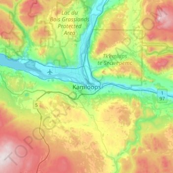
Name: Kamloops topographic map, elevation, terrain.
Average elevation: 875 m
Minimum elevation: 333 m
Maximum elevation: 1,885 m
Thompson-Nicola Regional District trails, hiking, mountain biking, running and outdoor activities
Other topographic maps
Click on a map to view its topography, its elevation and its terrain.
South Thompson River
Canada > British Columbia > Thompson-Nicola Regional District > Kamloops
Average elevation: 421 m
Valleyview Nature Park
Canada > British Columbia > Thompson-Nicola Regional District > Kamloops
Average elevation: 429 m