Geolocate

Picton topographic map

Click on the map to display elevation.

About this map

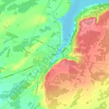
Name: Picton topographic map, elevation, terrain.

Location: Picton, Prince Edward County, Central Ontario, Ontario, M4N 1A5, Canada (43.96771 -77.18117 44.04771 -77.10117)

Average elevation: 112 m

Minimum elevation: 73 m

Maximum elevation: 157 m

Prince Edward County trails, hiking, mountain biking, running and outdoor activities

Other topographic maps

Click on a map to view its topography, its elevation and its terrain.

Bay of Quinte

Canada > Ontario > Prince Edward County

Average elevation: 99 m

Bay of Quinte

Canada > Ontario > Prince Edward County

Average elevation: 99 m

Gear up for your next adventure:

🎒Hiking Backpack - Lightweight and ergonomic backpacks for day hikes or multi-day treks
🛌Insulated Sleeping Pad - Critical thermal barrier between you and the cold ground
🥾Mountain Hiking Boots - High-traction boots for rocky terrain
🍽️Titanium Camping Spork - Ultralight and indestructible eating utensil
🌡️Emergency Mylar Blankets - Compact thermal protection for unexpected nights outdoors

As an Amazon Associate, this site earns from qualifying purchases at no extra cost to you.