
Mount Royal topographic map
Click on the map to display elevation.
Mount Royal
The hill is part of the Monteregian Hills situated between the Laurentians and the Appalachian Mountains. It gave its Latin name, Mons Regius, to the Monteregian chain. The hill consists of three peaks: Colline de la Croix (or Mont Royal proper) at 233 m (764 ft), Colline d'Outremont (or Mount Murray, in the borough of Outremont) at 211 m (692 ft), and Westmount Summit at 201 m (659 ft) elevation above mean sea level.
About this map
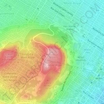
Name: Mount Royal topographic map, elevation, terrain.
Average elevation: 111 m
Minimum elevation: 35 m
Maximum elevation: 232 m
Urban agglomeration of Montreal trails, hiking, mountain biking, running and outdoor activities
Other topographic maps
Click on a map to view its topography, its elevation and its terrain.
Rivière des Prairies
Canada > Quebec > Urban agglomeration of Montreal > Montreal
Average elevation: 36 m
Rivière des Prairies
Canada > Quebec > Urban agglomeration of Montreal > Montreal
Average elevation: 34 m
Parc de la Rive-Boisée
Canada > Quebec > Urban agglomeration of Montreal > Montreal
Average elevation: 29 m
Notre Dame Island
Canada > Quebec > Urban agglomeration of Montreal > Montreal
Average elevation: 14 m
Rosemont–La Petite-Patrie
Canada > Quebec > Urban agglomeration of Montreal > Montreal
Average elevation: 50 m
Pierrefonds-Roxboro
Canada > Quebec > Urban agglomeration of Montreal > Montreal
Average elevation: 30 m
Parc Léon-Provancher
Canada > Quebec > Urban agglomeration of Montreal > Montreal
Average elevation: 53 m
Saint Helen's Island
Canada > Quebec > Urban agglomeration of Montreal > Montreal
Average elevation: 15 m
Le Plateau-Mont-Royal
Canada > Quebec > Urban agglomeration of Montreal > Montreal
Average elevation: 70 m
Parc-nature du Bois-de-Liesse
Canada > Quebec > Urban agglomeration of Montreal > Montreal
Average elevation: 28 m
Parc-nature de la Pointe-aux-Prairies
Canada > Quebec > Urban agglomeration of Montreal > Montreal
Average elevation: 12 m