
Great Dividing Range topographic map
Click on the map to display elevation.
Great Dividing Range
The Great Dividing Range, also known as the East Australian Cordillera or the Eastern Highlands, is a cordillera system in eastern Australia consisting of an expansive collection of mountain ranges, plateaus and rolling hills, that runs roughly parallel to the east coast of Australia and forms the fifth-longest land-based mountain chain in the world, and the longest entirely within a single country. It is mainland Australia's most substantial topographic feature and serves as the definitive watershed for the river systems in eastern Australia, hence the name.
About this map
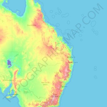
Name: Great Dividing Range topographic map, elevation, terrain.
Location: Great Dividing Range, Australia (-37.82225 142.45440 -13.66768 152.52520)
Average elevation: 117 m
Minimum elevation: -16 m
Maximum elevation: 1,959 m
Other topographic maps
Click on a map to view its topography, its elevation and its terrain.
Pennant Hills
Australia > New South Wales > Sydney
The name Pennant Hills originally applied to the area now known as West Pennant Hills, located in the Hills District. However, when the northern railway line was built it passed through what is now Pennant Hills, so a suburb grew around the station and took on the name. The area around Thompsons Corner was…
Average elevation: 146 m
Sydney International Regatta Centre
Australia > New South Wales > Sydney > Penrith > Upper Castlereagh
Average elevation: 19 m
Silver Valley
The locality is mountainous, rising from an elevation of 650 metres (2,130 ft) in Bulldog Gully in the south of the locality through to numerous peaks in the locality (from north to south).
Average elevation: 676 m
Horsham
Horsham's topography is flat, approximately 128 metres (420 ft) above sea level. The central business district (CBD) is laid out in a grid plan south of the train line and is characterised by wide streets and several roundabouts. Firebrace Street, running north–south through the middle of the CBD is one of…
Average elevation: 129 m