Geolocate

Victoria topographic map

Click on the map to display elevation.

About this map

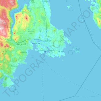
Name: Victoria topographic map, elevation, terrain.

Location: Victoria, Capital Regional District, British Columbia, V8W 1P6, Canada (48.26832 -123.52495 48.58832 -123.20495)

Average elevation: 47 m

Minimum elevation: -1 m

Maximum elevation: 607 m

Capital Regional District trails, hiking, mountain biking, running and outdoor activities

Other topographic maps

Click on a map to view its topography, its elevation and its terrain.

Gear up for your next adventure:

🥫Freeze-Dried Meals - Lightweight, high-calorie nutrition for multi-day treks
🔭Compact Binoculars - Lightweight optics for scouting trails and wildlife
🧥Fleece Jacket - Warm and lightweight jacket for layering
🦶Anti-Blister Balm - Prevents friction and hotspots during long ascents
🕶️Polarized Sunglasses - Reduces glare from snow and water at high elevations

As an Amazon Associate, this site earns from qualifying purchases at no extra cost to you.