
St. John's topographic map
Click on the map to display elevation.
About this map
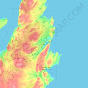
Name: St. John's topographic map, elevation, terrain.
Average elevation: 66 m
Minimum elevation: -1 m
Maximum elevation: 272 m
Newfoundland and Labrador trails, hiking, mountain biking, running and outdoor activities
Other topographic maps
Click on a map to view its topography, its elevation and its terrain.
Signal Hill National Historic Site
Canada > Newfoundland and Labrador > St. John's
Average elevation: 29 m
Memorial University of Newfoundland main campus
Canada > Newfoundland and Labrador > St. John's
Average elevation: 78 m