Geolocate

Nanaimo topographic map

Click on the map to display elevation.

About this map

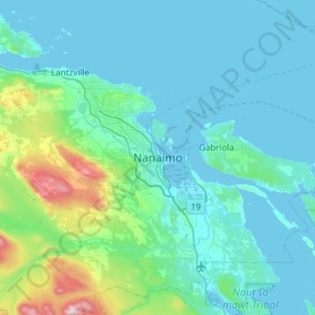
Name: Nanaimo topographic map, elevation, terrain.

Location: Nanaimo, British Columbia, V9R 5C7, Canada (49.00388 -124.09812 49.32388 -123.77812)

Average elevation: 142 m

Minimum elevation: -1 m

Maximum elevation: 1,227 m

British Columbia trails, hiking, mountain biking, running and outdoor activities

Gear up for your next adventure:

🚲Heavy Duty Bike Lock - Secure your bike at the trailhead or during stops
🥾Trekking Boots - Durable boots for long-distance trekking
🧭Orienteering Kit - Tools for map reading and navigation in the wild
💧Hydration Bladder - Hands-free hydration solution for long treks
🛁Quick-Dry Microfiber Towel - Space-saving towel that dries rapidly on the move

As an Amazon Associate, this site earns from qualifying purchases at no extra cost to you.