
Winnipeg (city) topographic map
Interactive map
Click on the map to display elevation.
About this map
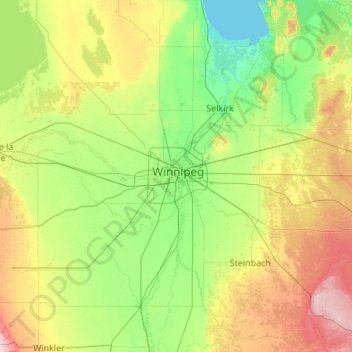
Name: Winnipeg (city) topographic map, elevation, terrain.
Location: Winnipeg (city), Manitoba, R3M 0S6, Canada (49.23229 -97.78912 50.51229 -96.50912)
Average elevation: 253 m
Minimum elevation: 215 m
Maximum elevation: 396 m
Other topographic maps
Click on a map to view its topography, its elevation and its terrain.
Winnipeg
Canada > Manitoba > Division No. 11
Winnipeg, Division No. 11, Manitoba, Canada
Average elevation: 236 m
Elphinstone
Canada > Manitoba > Division No. 15 > Rural Municipality of Yellowhead
Elphinstone, Rural Municipality of Yellowhead, Division No. 15, Manitoba, Canada
Average elevation: 583 m
West Shoal Lake
Canada > Manitoba > Division No. 18 > Rural Municipality of St. Laurent
West Shoal Lake, Rural Municipality of St. Laurent, Division No. 18, Manitoba, Canada
Average elevation: 262 m
Bakers Narrows
Canada > Manitoba > Division No. 21 > Unorganized Division No. 21
Bakers Narrows, Unorganized Division No. 21, Division No. 21, Manitoba, R8A 1N1, Canada
Average elevation: 297 m
Valley River
Canada > Manitoba > Division No. 16
Valley River, Division No. 16, Manitoba, Canada
Average elevation: 490 m
Ebb and Flow
Canada > Manitoba > Division No. 17
Ebb and Flow, Division No. 17, Manitoba, Canada
Average elevation: 261 m
Riding Mountain National Park
Riding Mountain National Park, Manitoba, Canada
Average elevation: 488 m
Bridal Lake
Canada > Manitoba > Division No. 23 > Unorganized Division No. 23
Bridal Lake, Unorganized Division No. 23, Division No. 23, Manitoba, Canada
Average elevation: 312 m
Lonesand
Canada > Manitoba > Division No. 1 > Rural Municipality of Stuartburn
Lonesand, Rural Municipality of Stuartburn, Division No. 1, Manitoba, Canada
Average elevation: 328 m
Bowsman
Canada > Manitoba > Division No. 20 > Rural Municipality of Minitonas – Bowsman
Bowsman, Rural Municipality of Minitonas – Bowsman, Division No. 20, Manitoba, Canada
Average elevation: 310 m
Municipality of North Norfolk
Canada > Manitoba > Division No. 8
Municipality of North Norfolk, Division No. 8, Manitoba, Canada
Average elevation: 316 m
Bélair
Canada > Manitoba > Division No. 1 > Rural Municipality of Alexander
Bélair, Rural Municipality of Alexander, Division No. 1, Manitoba, R0E 0E0, Canada
Average elevation: 256 m
Rural Municipality of East St. Paul
Canada > Manitoba > Division No. 13
Rural Municipality of East St. Paul, Division No. 13, Manitoba, Canada
Average elevation: 233 m
Charleswood--St. James--Assiniboia--Headingley
Canada > Manitoba > Division No. 11 > Winnipeg
Charleswood--St. James--Assiniboia--Headingley, Winnipeg, Rural Municipality of Headingley, Division No. 11, Manitoba, Canada
Average elevation: 238 m
Rural Municipality of Ste. Anne
Canada > Manitoba > Division No. 2
Rural Municipality of Ste. Anne, Division No. 2, Manitoba, R0E 1S0, Canada
Average elevation: 271 m
Rural Municipality of Sifton
Canada > Manitoba > Division No. 6
Rural Municipality of Sifton, Division No. 6, Manitoba, R0M 1P0, Canada
Average elevation: 431 m
Flin Flon
Canada > Manitoba > Division No. 21
Flin Flon, Division No. 21, Manitoba, Canada
Average elevation: 322 m
Altona
Canada > Manitoba > Division No. 3
Altona, Division No. 3, Manitoba, R0G 0B0, Canada
Average elevation: 248 m
Wawanesa
Canada > Manitoba > Division No. 7
Wawanesa, Division No. 7, Manitoba, R0K 2G0, Canada
Average elevation: 375 m
Unorganized Division No. 17
Canada > Manitoba > Division No. 17
Unorganized Division No. 17, Division No. 17, Manitoba, Canada
Average elevation: 513 m
Rural Municipality of Coldwell
Canada > Manitoba > Division No. 18
Rural Municipality of Coldwell, Division No. 18, Manitoba, R0C 1Y0, Canada
Average elevation: 260 m
Rowland Lake
Canada > Manitoba > Division No. 15 > Rural Municipality of Rosedale
Rowland Lake, Rural Municipality of Rosedale, Division No. 15, Manitoba, Canada
Average elevation: 692 m
Gunton
Canada > Manitoba > Division No. 14
Gunton, Rural Municipality of Rockwood, Division No. 14, Manitoba, Canada
Average elevation: 254 m
Rural Municipality of Grey
Canada > Manitoba > Division No. 9
Rural Municipality of Grey, Division No. 9, Manitoba, Canada
Average elevation: 269 m
Swan Lake
Canada > Manitoba > Division No. 4 > Municipality of Lorne
Swan Lake, Municipality of Lorne, Division No. 4, Manitoba, Canada
Average elevation: 465 m
Municipality of Harrison Park
Canada > Manitoba > Division No. 15
Municipality of Harrison Park, Division No. 15, Manitoba, Canada
Average elevation: 615 m
Hillside Beach
Canada > Manitoba > Division No. 1 > Rural Municipality of Alexander
Hillside Beach, Rural Municipality of Alexander, Division No. 1, Manitoba, R0E 2A0, Canada
Average elevation: 225 m
Easterville
Canada > Manitoba > Division No. 21 > Unorganized Division No. 21
Easterville, Unorganized Division No. 21, Division No. 21, Manitoba, Canada
Average elevation: 260 m
Laurie River;Tod Lake
Canada > Manitoba > Division No. 23 > Unorganized Division No. 23
Laurie River;Tod Lake, Unorganized Division No. 23, Division No. 23, Manitoba, Canada
Average elevation: 362 m
Miniota
Canada > Manitoba > Division No. 15 > Prairie View Municipality
Miniota, Prairie View Municipality, Division No. 15, Manitoba, R0M 1M0, Canada
Average elevation: 434 m
Clearwater
Canada > Manitoba > Division No. 4 > Municipality of Louise
Clearwater, Municipality of Louise, Division No. 4, Manitoba, Canada
Average elevation: 454 m
Municipality of Russell – Binscarth
Canada > Manitoba > Division No. 16
Municipality of Russell – Binscarth, Division No. 16, Manitoba, Canada
Average elevation: 520 m
McCreary
Canada > Manitoba > Division No. 17
McCreary, Division No. 17, Manitoba, R0J 1B0, Canada
Average elevation: 304 m
Clear Lake
Canada > Manitoba > Division No. 18 > Rural Municipality of Grahamdale
Clear Lake, Rural Municipality of Grahamdale, Division No. 18, Manitoba, Canada
Average elevation: 251 m
Carman
Canada > Manitoba > Division No. 3
Carman, Division No. 3, Manitoba, R0G 0J0, Canada
Average elevation: 265 m
Fairford
Canada > Manitoba > Division No. 18
Fairford, Division No. 18, Manitoba, R0C 0X0, Canada
Average elevation: 251 m
Rural Municipality of Minto - Odanah
Canada > Manitoba > Division No. 15
Rural Municipality of Minto - Odanah, Division No. 15, Manitoba, Canada, Jacksons Lake
Average elevation: 587 m
Unorganized Division No. 21
Canada > Manitoba > Division No. 21
Unorganized Division No. 21, Division No. 21, Manitoba, Canada, Syme Lake
Average elevation: 333 m
Athapapuskow Lake
Athapapuskow Lake, Snoman Trail, Manitoba, R8A, Canada
Average elevation: 306 m
Vassar
Canada > Manitoba > Division No. 1 > Rural Municipality of Piney
Vassar, Rural Municipality of Piney, Division No. 1, Manitoba, Canada
Average elevation: 358 m
Waskada
Canada > Manitoba > Division No. 5
Waskada, Division No. 5, Manitoba, Canada
Average elevation: 473 m
Swan River
Canada > Manitoba > Division No. 20
Swan River, Division No. 20, Manitoba, Canada
Average elevation: 340 m
Libau
Canada > Manitoba > Division No. 13 > Rural Municipality of St. Clements
Libau, Rural Municipality of St. Clements, Division No. 13, Manitoba, Canada
Average elevation: 223 m
Nutimik Lake
Canada > Manitoba > Division No. 1 > Unorganized Division No. 1
Nutimik Lake, Unorganized Division No. 1, Division No. 1, Manitoba, Canada
Average elevation: 282 m