
Make a donation
Gear up for your next adventure:
As an Amazon Associate, this site earns from qualifying purchases at no extra cost to you.
Poland topographic map
Click on the map to display elevation.
Make a donation
Gear up for your next adventure:
As an Amazon Associate, this site earns from qualifying purchases at no extra cost to you.
Poland
Poland's topography is characterized by a diverse landscape that transitions from the Baltic Sea's sandy beaches in the north to mountainous regions in the south. The northern coastline features sand dunes and is indented by spits and lagoons, such as the Hel Peninsula and the Vistula Lagoon. Moving inland, the terrain is shaped by glacial activity, resulting in numerous lakes and gentle hills, particularly evident in the Masurian Lake District, which boasts over 2,000 lakes amidst dense forests. Central Poland is dominated by the expansive Polish Plain, a flat region crisscrossed by major rivers like the Vistula and the Oder, making it ideal for agriculture. Further south, the landscape becomes more varied with uplands and highlands, including the Lesser Poland Uplands, characterized by rolling hills and fertile valleys. The southernmost part of the country is marked by the Sudeten and Carpathian mountain ranges. The Carpathians encompass the Tatra Mountains, where Poland's highest peak, Mount Rysy, reaches 2,501 meters (8,205 feet). This diverse terrain supports a rich array of ecosystems and contributes to Poland's varied climate patterns.
Make a donation
Gear up for your next adventure:
As an Amazon Associate, this site earns from qualifying purchases at no extra cost to you.
About this map
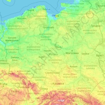
Name: Poland topographic map, elevation, terrain.
Location: Poland (49.00205 14.06964 55.03605 24.14578)
Average elevation: 194 m
Minimum elevation: -6 m
Maximum elevation: 2,237 m
Make a donation
Gear up for your next adventure:
As an Amazon Associate, this site earns from qualifying purchases at no extra cost to you.
Other topographic maps
Click on a map to view its topography, its elevation and its terrain.
Toronto
Despite its deep ravines, Toronto is not remarkably hilly, but its elevation does increase steadily away from the lake. Elevation differences range from 76.5 metres (251 ft) above sea level at the Lake Ontario shore to 209 m (686 ft) ASL near the York University grounds in the city's north end at the…
Average elevation: 113 m
Make a donation
Gear up for your next adventure:
As an Amazon Associate, this site earns from qualifying purchases at no extra cost to you.
Banff
Canada > Alberta > Banff > Banff
Banff is a town within Banff National Park in Alberta, Canada. It is located in Alberta's Rockies along the Trans-Canada Highway, approximately 126 km (78 mi) west of Calgary and 58 km (36 mi) east of Lake Louise. At 1,400 to 1,630 m (4,590 to 5,350 ft) above sea level, Banff is the community with the second…
Average elevation: 1,615 m
Make a donation
Gear up for your next adventure:
As an Amazon Associate, this site earns from qualifying purchases at no extra cost to you.
Peterborough
Canada > Ontario > Peterborough
Peterborough's topography is largely defined by land formations created by the receding Wisconsian glaciers 10,000–15,000 years ago. The South End and Downtown portions of the City sit on what was the bottom of the glacial Lake Peterborough—part of a glacial spillway created when glacial meltwaters from…
Average elevation: 235 m
Lethbridge
Canada > Alberta > Lethbridge
Its high elevation of 929 m (3,047.9 ft) and close proximity to the Rocky Mountains provides Lethbridge with cooler summers than other locations in the Canadian Prairies. These factors protect the city from strong northwest and southwest winds and contribute to frequent chinook winds during the winter.…
Average elevation: 918 m
Salt Lake City
United States > Utah > Salt Lake County > Salt Lake City
Salt Lake City has an area of 110.4 square miles (286 km2) and an average elevation of 4,327 feet (1,319 m) above sea level. The lowest point within the boundaries of the city is 4,210 feet (1,280 m) near the Jordan River and the Great Salt Lake, and the highest is Grandview Peak, at 9,410 feet (2,868 m).
Average elevation: 1,625 m
Make a donation
Gear up for your next adventure:
As an Amazon Associate, this site earns from qualifying purchases at no extra cost to you.
Puducherry
India > Puducherry > Puducherry Taluk
The topography of Pondicherry is the same as that of coastal Tamil Nadu. Pondicherry's average elevation is at sea level and includes a number of sea inlets, referred to locally as "backwaters". Pondicherry experiences extreme coastal erosion as a result of a breakwater constructed in 1989, just to the south…
Average elevation: 10 m
London
Canada > Ontario > London > London
London has a humid continental climate (Köppen Dfb), though due to its downwind location relative to Lake Huron and elevation changes across the city, it is virtually on the Dfa/Dfb (hot summer) boundary favouring the former climate zone to the southwest of the confluence of the South and North Thames Rivers,…
Average elevation: 268 m
Make a donation
Gear up for your next adventure:
As an Amazon Associate, this site earns from qualifying purchases at no extra cost to you.
Lake Louise
Canada > Alberta > Improvement District No. 9
Lake Louise is a hamlet within Banff National Park in Alberta, Canada. Named after Princess Louise, Duchess of Argyll, it lies in Alberta's Rockies on the Bow River, 3 km (1.9 mi) northeast of the lake that shares its name. Initially settled in 1884 as an outpost for the Canadian Pacific Railway, Lake Louise…
Average elevation: 1,617 m
Make a donation
Gear up for your next adventure:
As an Amazon Associate, this site earns from qualifying purchases at no extra cost to you.
Make a donation
Gear up for your next adventure:
As an Amazon Associate, this site earns from qualifying purchases at no extra cost to you.
Kamloops
Canada > British Columbia > Thompson-Nicola Regional District > Kamloops
Average elevation: 875 m
Make a donation
Gear up for your next adventure:
As an Amazon Associate, this site earns from qualifying purchases at no extra cost to you.
Guelph
This region of Ontario has cold winters and warm, humid summers, falling into the Köppen climate classification Dfb zone, with moderately high rainfall and snowfall. It is generally a couple of degrees cooler than lower elevation regions on the Great Lakes shorelines, especially so in winter, the exception…
Average elevation: 344 m
Make a donation
Gear up for your next adventure:
As an Amazon Associate, this site earns from qualifying purchases at no extra cost to you.
Stanley Park
Canada > British Columbia > Metro Vancouver Regional District > Vancouver
Average elevation: 14 m
Fairmont Hot Springs
Canada > British Columbia > Regional District of East Kootenay > Area F (Columbia Lake/Windermere Lake)
Average elevation: 920 m
Make a donation
Gear up for your next adventure:
As an Amazon Associate, this site earns from qualifying purchases at no extra cost to you.
Annapolis Valley
Canada > Nova Scotia > Municipality of the County of Kings > Auburn
Average elevation: 77 m
Nova Scotia peninsula
Canada > Nova Scotia > Hants County > Upper Rawdon
The Cobequid Mountains contain the highest elevation points on the peninsula. This low, heavily eroded part of the Appalachian Mountains, along with the Pictou-Antigonish Highlands, comprises a highland across the northern portion of the peninsula with average elevations between 250–300 metres. It was…
Average elevation: 118 m
Whistler
Canada > British Columbia > Squamish-Lillooet Regional District > Whistler Resort Municipality > Whistler
Average elevation: 996 m
Make a donation
Gear up for your next adventure:
As an Amazon Associate, this site earns from qualifying purchases at no extra cost to you.
Make a donation
Gear up for your next adventure:
As an Amazon Associate, this site earns from qualifying purchases at no extra cost to you.
Whiskey Creek
Canada > British Columbia > Regional District of Nanaimo > Area F (Alberni Highway)
Average elevation: 126 m
Cedar
Canada > British Columbia > Regional District of Nanaimo > Area A (Cassidy/Cedar)
Average elevation: 27 m
Make a donation
Gear up for your next adventure:
As an Amazon Associate, this site earns from qualifying purchases at no extra cost to you.
Laurentian Mountains
One of Quebec's official regions is called Laurentides. The mountain range runs through four other regions; Capitale-Nationale, Outaouais, Lanaudière, and Mauricie. The elevation generally ranges from around 500 m (1,640 ft) to 1,000 m (3,280 ft) with Mont Raoul-Blanchard being its highest peak, at 1,166 m…
Average elevation: 348 m
Elk River
Canada > British Columbia > Regional District of East Kootenay > Fernie
Average elevation: 1,134 m
Bowsman
Canada > Manitoba > Division No. 20 > Rural Municipality of Minitonas – Bowsman
Average elevation: 310 m
Make a donation
Gear up for your next adventure:
As an Amazon Associate, this site earns from qualifying purchases at no extra cost to you.
Salmon Arm
Canada > British Columbia > Columbia-Shuswap Regional District > Salmon Arm > Salmon Arm
Average elevation: 479 m
Make a donation
Gear up for your next adventure:
As an Amazon Associate, this site earns from qualifying purchases at no extra cost to you.
Royston
Canada > British Columbia > Comox Valley Regional District > Area A (Baynes Sound)
Average elevation: 29 m
Make a donation
Gear up for your next adventure:
As an Amazon Associate, this site earns from qualifying purchases at no extra cost to you.
Caribbean
Rainfall varies with elevation, size and water currents, such as the cool upwellings that keep the ABC islands arid. Warm, moist trade winds blow consistently from the east, creating both rain forest and semi arid climates across the region. The tropical rainforest climates include lowland areas near the…
Average elevation: 20 m
Make a donation
Gear up for your next adventure:
As an Amazon Associate, this site earns from qualifying purchases at no extra cost to you.
Nose Hill Park
Names currently associated with topographical features in and near Nose Hill Park reflect the impact of the European newcomers and European trade goods on the Peigan. For example, Spy Hill, the westward extension of Nose Hill, derived its present name from the aboriginal practice of communicating with distant…
Average elevation: 1,174 m
Falkland
Canada > British Columbia > Columbia-Shuswap Regional District > Area D (Falkland/Silver Creek)
Average elevation: 786 m
Make a donation
Gear up for your next adventure:
As an Amazon Associate, this site earns from qualifying purchases at no extra cost to you.
Burnaby Mountain
Canada > British Columbia > Metro Vancouver Regional District > Burnaby
Due to its relatively high elevation, snow will often fall on the higher levels of Burnaby Mountain while rain falls in the surrounding cities. Tobogganing is a popular pastime at Centennial Park on winter days with snow.
Average elevation: 167 m
Make a donation
Gear up for your next adventure:
As an Amazon Associate, this site earns from qualifying purchases at no extra cost to you.
Canmore
Canada > Alberta > Town of Canmore
Elevation Place opened in April 2013 as Canmore's new recreation facility. Construction of the facility began in 2012 to replace the Canmore Recreation Centre (the community's old facility). The facility offers an 8-lane 25m lap pool, a world class climbing wall developed by Walltopia, two cardio rooms, a…
Average elevation: 1,565 m
Kootenay Columbia
Canada > British Columbia > Regional District of Kootenay Boundary > Area B (Lower Columbia/Old Glory)
Average elevation: 1,013 m
Errington
Canada > British Columbia > Regional District of Nanaimo > Area F (Alberni Highway)
Average elevation: 120 m
Make a donation
Gear up for your next adventure:
As an Amazon Associate, this site earns from qualifying purchases at no extra cost to you.
Make a donation
Gear up for your next adventure:
As an Amazon Associate, this site earns from qualifying purchases at no extra cost to you.
Steelhead
Canada > British Columbia > Fraser Valley Regional District > Mission
Average elevation: 293 m
Make a donation
Gear up for your next adventure:
As an Amazon Associate, this site earns from qualifying purchases at no extra cost to you.
Barkerville
Canada > British Columbia > Cariboo Regional District > Area C (Bowron Lake/Barlow Creek/Barkerville)
Barkerville has a subarctic climate (Köppen climate classification Dfc), which makes it have long, cold and snowy winter and short and cool summers due to its high altitude and latitude. Its growing season averages only 66 days.
Average elevation: 1,435 m
Cape Town
South Africa > Western Cape > City of Cape Town
The Cape Peninsula is 52 km long from Mouille Point in the north to Cape Point in the south, with an area of about 470 km2, and it displays more topographical variety than other similar sized areas in southern Africa, and consequently spectacular scenery. There are diverse low-nutrient soils, large rocky…
Average elevation: 53 m
Make a donation
Gear up for your next adventure:
As an Amazon Associate, this site earns from qualifying purchases at no extra cost to you.
Madawaska River
Canada > Ontario > Renfrew County > Greater Madawaska > Calabogie
Average elevation: 160 m
Make a donation
Gear up for your next adventure:
As an Amazon Associate, this site earns from qualifying purchases at no extra cost to you.
Courtenay
Canada > British Columbia > Comox Valley Regional District > Courtenay
Average elevation: 187 m
Make a donation
Gear up for your next adventure:
As an Amazon Associate, this site earns from qualifying purchases at no extra cost to you.
Burnaby
Canada > British Columbia > Metro Vancouver Regional District > Burnaby
Burnaby occupies 98.60 square kilometres (38.07 sq mi) and is located at the geographic centre of the Metro Vancouver area and home to the Metro Vancouver regional government in Metrotown. Situated between the city of Vancouver on the west and Port Moody, Coquitlam, and New Westminster on the east, Burnaby is…
Average elevation: 144 m
Mount Washington
Canada > British Columbia > Comox Valley Regional District > Area C (Puntledge/Black Creek)
Average elevation: 1,279 m
Great Dividing Range
The Great Dividing Range, also known as the East Australian Cordillera or the Eastern Highlands, is a cordillera system in eastern Australia consisting of an expansive collection of mountain ranges, plateaus and rolling hills, that runs roughly parallel to the east coast of Australia and forms the…
Average elevation: 117 m
Make a donation
Gear up for your next adventure:
As an Amazon Associate, this site earns from qualifying purchases at no extra cost to you.