
Make a donation
Gear up for your next adventure:
As an Amazon Associate, this site earns from qualifying purchases at no extra cost to you.
Yukon topographic map
Click on the map to display elevation.
Make a donation
Gear up for your next adventure:
As an Amazon Associate, this site earns from qualifying purchases at no extra cost to you.
About this map
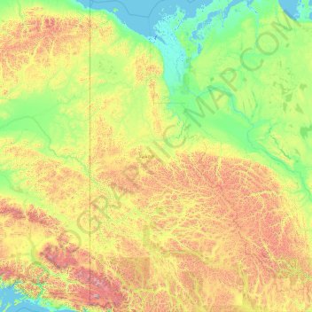
Name: Yukon topographic map, elevation, terrain.
Location: Yukon, Canada (59.99854 -141.00275 69.84588 -123.81025)
Average elevation: 723 m
Minimum elevation: -3 m
Maximum elevation: 5,610 m
Canada trails, hiking, mountain biking, running and outdoor activities
Make a donation
Gear up for your next adventure:
As an Amazon Associate, this site earns from qualifying purchases at no extra cost to you.
Other topographic maps
Click on a map to view its topography, its elevation and its terrain.
Toronto
Despite its deep ravines, Toronto is not remarkably hilly, but its elevation does increase steadily away from the lake. Elevation differences range from 76.5 metres (251 ft) above sea level at the Lake Ontario shore to 209 m (686 ft) ASL near the York University grounds in the city's north end at the…
Average elevation: 113 m
Guelph
This region of Ontario has cold winters and warm, humid summers, falling into the Köppen climate classification Dfb zone, with moderately high rainfall and snowfall. It is generally a couple of degrees cooler than lower elevation regions on the Great Lakes shorelines, especially so in winter, the exception…
Average elevation: 344 m
Make a donation
Gear up for your next adventure:
As an Amazon Associate, this site earns from qualifying purchases at no extra cost to you.
London
Canada > Ontario > London > London
London has a humid continental climate (Köppen Dfb), though due to its downwind location relative to Lake Huron and elevation changes across the city, it is virtually on the Dfa/Dfb (hot summer) boundary favouring the former climate zone to the southwest of the confluence of the South and North Thames Rivers,…
Average elevation: 268 m
Make a donation
Gear up for your next adventure:
As an Amazon Associate, this site earns from qualifying purchases at no extra cost to you.
Banff
Canada > Alberta > Banff > Banff
Banff is a town within Banff National Park in Alberta, Canada. It is located in Alberta's Rockies along the Trans-Canada Highway, approximately 126 km (78 mi) west of Calgary and 58 km (36 mi) east of Lake Louise. At 1,400 to 1,630 m (4,590 to 5,350 ft) above sea level, Banff is the community with the second…
Average elevation: 1,615 m
Make a donation
Gear up for your next adventure:
As an Amazon Associate, this site earns from qualifying purchases at no extra cost to you.
Lake Louise
Canada > Alberta > Improvement District No. 9
Lake Louise is a hamlet within Banff National Park in Alberta, Canada. Named after Princess Louise, Duchess of Argyll, it lies in Alberta's Rockies on the Bow River, 3 km (1.9 mi) northeast of the lake that shares its name. Initially settled in 1884 as an outpost for the Canadian Pacific Railway, Lake Louise…
Average elevation: 1,617 m
Kamloops
Canada > British Columbia > Thompson-Nicola Regional District > Kamloops
Average elevation: 875 m
Make a donation
Gear up for your next adventure:
As an Amazon Associate, this site earns from qualifying purchases at no extra cost to you.
Canmore
Canada > Alberta > Town of Canmore
Elevation Place opened in April 2013 as Canmore's new recreation facility. Construction of the facility began in 2012 to replace the Canmore Recreation Centre (the community's old facility). The facility offers an 8-lane 25m lap pool, a world class climbing wall developed by Walltopia, two cardio rooms, a…
Average elevation: 1,565 m
Make a donation
Gear up for your next adventure:
As an Amazon Associate, this site earns from qualifying purchases at no extra cost to you.
Make a donation
Gear up for your next adventure:
As an Amazon Associate, this site earns from qualifying purchases at no extra cost to you.
Nose Hill Park
Names currently associated with topographical features in and near Nose Hill Park reflect the impact of the European newcomers and European trade goods on the Peigan. For example, Spy Hill, the westward extension of Nose Hill, derived its present name from the aboriginal practice of communicating with distant…
Average elevation: 1,174 m
North Mountain
Canada > Nova Scotia > Municipality of the County of Annapolis > Port Royal
Average elevation: 134 m
Make a donation
Gear up for your next adventure:
As an Amazon Associate, this site earns from qualifying purchases at no extra cost to you.
Fairmont Hot Springs
Canada > British Columbia > Regional District of East Kootenay > Area F (Columbia Lake/Windermere Lake)
Average elevation: 920 m
Make a donation
Gear up for your next adventure:
As an Amazon Associate, this site earns from qualifying purchases at no extra cost to you.
Make a donation
Gear up for your next adventure:
As an Amazon Associate, this site earns from qualifying purchases at no extra cost to you.
Laurentian Mountains
One of Quebec's official regions is called Laurentides. The mountain range runs through four other regions; Capitale-Nationale, Outaouais, Lanaudière, and Mauricie. The elevation generally ranges from around 500 m (1,640 ft) to 1,000 m (3,280 ft) with Mont Raoul-Blanchard being its highest peak, at 1,166 m…
Average elevation: 348 m
5040 Peak
Canada > British Columbia > Alberni-Clayoquot Regional District > Area D (Sproat Lake)
Average elevation: 1,092 m
Make a donation
Gear up for your next adventure:
As an Amazon Associate, this site earns from qualifying purchases at no extra cost to you.
Barnet Marine Park
Canada > British Columbia > Metro Vancouver Regional District > Burnaby
Average elevation: 95 m
Make a donation
Gear up for your next adventure:
As an Amazon Associate, this site earns from qualifying purchases at no extra cost to you.
Grande Prairie
Canada > Alberta > Grande Prairie
Grande Prairie is located just north of the 55th parallel north, and is 465 km (289 mi) northwest of Edmonton, lying at an elevation of 669 m (2,195 ft) above sea level. The city is surrounded by farmland to the north, east, and west. To the south lies a vast boreal forest with aspen, tamarack, lodgepole pine,…
Average elevation: 668 m
Make a donation
Gear up for your next adventure:
As an Amazon Associate, this site earns from qualifying purchases at no extra cost to you.
Bird River
Canada > Manitoba > Division No. 1 > Rural Municipality of Alexander
Average elevation: 287 m
Grindrod
Canada > British Columbia > Regional District of North Okanagan > Area F (Grindrod/Ashton Creek/Mabel Lake)
Average elevation: 406 m
Make a donation
Gear up for your next adventure:
As an Amazon Associate, this site earns from qualifying purchases at no extra cost to you.
Make a donation
Gear up for your next adventure:
As an Amazon Associate, this site earns from qualifying purchases at no extra cost to you.
Riding Mountain National Park
Canada > Manitoba > Municipality of Harrison Park > Wasagaming
Riding Mountain Biosphere Reserve covers 15,000 square kilometers of land in South-western Manitoba, with the core area, Riding Mountain National Park (RMNP), covering nearly 3,000 square kilometers. It is some 300 km northwest of Winnipeg, Manitoba. The local climate is cool and moist due to a higher…
Average elevation: 623 m
Make a donation
Gear up for your next adventure:
As an Amazon Associate, this site earns from qualifying purchases at no extra cost to you.
Rocky Mountains
Canada > British Columbia > Northern Rockies Regional Municipality
Average elevation: 1,329 m
Crescent Beach
Canada > British Columbia > Metro Vancouver Regional District > Surrey
Average elevation: 22 m
Make a donation
Gear up for your next adventure:
As an Amazon Associate, this site earns from qualifying purchases at no extra cost to you.
Little Crosby Lake
Canada > Ontario > Leeds and Grenville Counties > Rideau Lakes
Average elevation: 166 m
Pritchard
Canada > British Columbia > Thompson-Nicola Regional District > Area P (Rivers and the Peaks)
Average elevation: 433 m
Make a donation
Gear up for your next adventure:
As an Amazon Associate, this site earns from qualifying purchases at no extra cost to you.
Vernon
Canada > British Columbia > Regional District of North Okanagan > Vernon
Average elevation: 852 m
Steeples
Canada > British Columbia > Regional District of East Kootenay > Cranbrook
Average elevation: 940 m
Make a donation
Gear up for your next adventure:
As an Amazon Associate, this site earns from qualifying purchases at no extra cost to you.
Sunshine Valley
Canada > British Columbia > Fraser Valley Regional District > Area B (South Fraser Canyon/Sunshine Valley)
Average elevation: 1,030 m
Make a donation
Gear up for your next adventure:
As an Amazon Associate, this site earns from qualifying purchases at no extra cost to you.
Elkwater
Canada > Alberta > Cypress County
The Elkwater townsite lies at an elevation of about 1,225 m (4,025 ft) on the northwest slope of the Cypress Hills which, with a summit at 1,466 m (4810 ft), are the highest point between the Rocky Mountains and Labrador within Canada. Because of the elevation, the area receives more moisture than the…
Average elevation: 1,294 m
Roberts Creek
Canada > British Columbia > Sunshine Coast Regional District > Area D (Roberts Creek)
Average elevation: 56 m
Make a donation
Gear up for your next adventure:
As an Amazon Associate, this site earns from qualifying purchases at no extra cost to you.
Grouse Mountain
Canada > British Columbia > Metro Vancouver Regional District
Grouse Mountain is one of the North Shore Mountains of the Pacific Ranges in the District Municipality of North Vancouver, British Columbia, Canada. With a maximum elevation of over 1,200 m (4,100 feet) at its peak, the mountain is the site of an alpine ski area, Grouse Mountain Resort, which overlooks Greater…
Average elevation: 968 m
Make a donation
Gear up for your next adventure:
As an Amazon Associate, this site earns from qualifying purchases at no extra cost to you.
Silent Lake Provincial Park
Canada > Ontario > Haliburton County > Highlands East
Average elevation: 371 m
Lethbridge
Canada > Alberta > Lethbridge
Its high elevation of 929 m (3,047.9 ft) and close proximity to the Rocky Mountains provides Lethbridge with cooler summers than other locations in the Canadian Prairies. These factors protect the city from strong northwest and southwest winds and contribute to frequent chinook winds during the winter.…
Average elevation: 918 m
Make a donation
Gear up for your next adventure:
As an Amazon Associate, this site earns from qualifying purchases at no extra cost to you.
Make a donation
Gear up for your next adventure:
As an Amazon Associate, this site earns from qualifying purchases at no extra cost to you.
Make a donation
Gear up for your next adventure:
As an Amazon Associate, this site earns from qualifying purchases at no extra cost to you.
Peterborough
Canada > Ontario > Peterborough
Peterborough's topography is largely defined by land formations created by the receding Wisconsian glaciers 10,000–15,000 years ago. The South End and Downtown portions of the City sit on what was the bottom of the glacial Lake Peterborough—part of a glacial spillway created when glacial meltwaters from…
Average elevation: 235 m
Make a donation
Gear up for your next adventure:
As an Amazon Associate, this site earns from qualifying purchases at no extra cost to you.