
Valley River topographic map
Click on the map to display elevation.
About this map
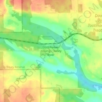
Name: Valley River topographic map, elevation, terrain.
Location: Valley River, Division No. 16, Manitoba, Canada (51.20847 -100.99030 51.24847 -100.95030)
Average elevation: 490 m
Minimum elevation: 467 m
Maximum elevation: 513 m
Division No. 16 trails, hiking, mountain biking, running and outdoor activities
Other topographic maps
Click on a map to view its topography, its elevation and its terrain.
Lake of the Prairies
Canada > Manitoba > Division No. 16 > Rural Municipality of Riding Mountain West
Average elevation: 502 m