Geolocate

New Brunswick topographic map

Interactive map

Click on the map to display elevation.

About this map

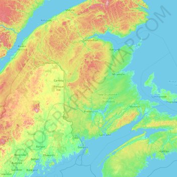
Name: New Brunswick topographic map, elevation, terrain.

Location: New Brunswick, Canada (43.94028 -69.31018 49.06028 -64.19018)

Average elevation: 165 m

Minimum elevation: -3 m

Maximum elevation: 1,412 m

New Brunswick trails, hiking, mountain biking, running and outdoor activities

Other topographic maps

Click on a map to view its topography, its elevation and its terrain.

Fredericton

Canada > New Brunswick > Kingsclear Parish > Fredericton

At an altitude of about 17 m (56 ft) above sea level, Fredericton is nestled in the Pennsylvanian Basin. It differs markedly from the geologically older parts of the province. There are prominently two distinct areas in the region that are divided around the area of Wilsey Road, in the east end of the city. In…

Average elevation: 72 m

Moncton

Canada > New Brunswick > Moncton Parish

Average elevation: 52 m

Hampton Parish

Canada > New Brunswick

Average elevation: 86 m

Saint John

Canada > New Brunswick > Saint John

Average elevation: 39 m

Edmundston

Canada > New Brunswick > Madawaska Parish

Edmundston has a downhill skiing facility in the city at Mont Farlagne. This facility has 3 lifts, a t-bar, a double chair, and a quad chair. It has 14 trails and an elevation of 690 feet. Snowmaking is available. Five trails are lit for night skiing.

Average elevation: 256 m

Denmark Parish

Canada > New Brunswick

Average elevation: 266 m

Fredericton

Canada > New Brunswick > York County

At an altitude of about 17 m (56 ft) above sea level, Fredericton is nestled in the Pennsylvanian Basin. It differs markedly from the geologically older parts of the province. There are prominently two distinct areas in the region that are divided around the area of Wilsey Road, in the east end of the city. In…

Average elevation: 73 m

Millville

Canada > New Brunswick > Southampton Parish

Average elevation: 172 m

Neguac

Canada > New Brunswick > Alnwick Parish

Average elevation: 13 m

Beresford

Canada > New Brunswick > Beresford Parish

Average elevation: 18 m

St. John River

Canada > New Brunswick

Average elevation: 76 m

Restigouche County

Canada > New Brunswick

Average elevation: 306 m

Fredericton

Canada > New Brunswick > York County

At an altitude of about 17 m (56 ft) above sea level, Fredericton is nestled in the Pennsylvanian Basin. It differs markedly from the geologically older parts of the province. There are prominently two distinct areas in the region that are divided around the area of Wilsey Road, in the east end of the city. In…

Average elevation: 73 m

Bas-Caraquet

Canada > New Brunswick > Caraquet Parish

Average elevation: 6 m

Hopewell Parish

Canada > New Brunswick

Average elevation: 128 m

Rexton

Canada > New Brunswick > Richibucto Parish

Average elevation: 5 m

Bright Parish

Canada > New Brunswick

Average elevation: 171 m

Restigouche County

Canada > New Brunswick

Average elevation: 306 m

Sussex Parish

Canada > New Brunswick

Average elevation: 129 m

Woodstock

Canada > New Brunswick > Woodstock Parish

Average elevation: 95 m

Bathurst

Canada > New Brunswick > Gloucester County

Average elevation: 26 m

Oromocto

Canada > New Brunswick > Burton Parish

Average elevation: 24 m

Newcastle Parish

Canada > New Brunswick

Average elevation: 86 m

St. George

Canada > New Brunswick > Charlotte County

Average elevation: 33 m

Perth-Andover

Canada > New Brunswick > Andover Parish

Average elevation: 169 m

Heron Island

Canada > New Brunswick > Durham Parish

Average elevation: 1 m

Edmundston

Canada > New Brunswick > Madawaska Parish

Edmundston has a downhill skiing facility in the city at Mont Farlagne. This facility has 3 lifts, a t-bar, a double chair, and a quad chair. It has 14 trails and an elevation of 690 feet. Snowmaking is available. Five trails are lit for night skiing.

Average elevation: 256 m

Canterbury Parish

Canada > New Brunswick

Average elevation: 173 m

Hoyt Nub

Canada > New Brunswick > Saint George Parish

Average elevation: 6 m

Kent Parish

Canada > New Brunswick

Average elevation: 284 m

Miramichi

Canada > New Brunswick > Miramichi

Average elevation: 46 m

Southampton Parish

Canada > New Brunswick

Average elevation: 166 m

Kings County

Canada > New Brunswick

Average elevation: 90 m

Rivière-Verte Parish

Canada > New Brunswick

Average elevation: 310 m

Blackville

Canada > New Brunswick > Blackville Parish

Average elevation: 52 m

Wellington Parish

Canada > New Brunswick

Average elevation: 26 m

Saint-Andre Parish

Canada > New Brunswick

Average elevation: 232 m

Neguac

Canada > New Brunswick > Alnwick Parish

Average elevation: 13 m

Edmundston

Canada > New Brunswick > Edmundston

Edmundston has a downhill skiing facility in the city at Mont Farlagne. This facility has 3 lifts, a t-bar, a double chair, and a quad chair. It has 14 trails and an elevation of 690 feet. Snowmaking is available. Five trails are lit for night skiing.

Average elevation: 256 m

Lorne Parish

Canada > New Brunswick

Average elevation: 339 m

Sainte-Anne Parish

Canada > New Brunswick

Average elevation: 278 m

Cap-Pele

Canada > New Brunswick > Shediac Parish

Average elevation: 13 m

Mount Whatly

Canada > New Brunswick > Sackville Parish

Average elevation: 18 m

Nigadoo

Canada > New Brunswick > Beresford Parish

Average elevation: 12 m

Bay of Fundy

Canada > New Brunswick

Average elevation: 52 m

Quispamsis

Canada > New Brunswick > Rothesay Parish

Average elevation: 54 m

Tracy

Canada > New Brunswick > Gladstone Parish

Average elevation: 51 m

Newcastle

Canada > New Brunswick > City of Miramichi > Miramichi

Average elevation: 57 m

Blackville

Canada > New Brunswick > Blackville Parish

Average elevation: 52 m

Greenwich Parish

Canada > New Brunswick

Average elevation: 95 m

Shediac

Canada > New Brunswick > Shediac Parish

Average elevation: 17 m

Hanwell

Canada > New Brunswick > Kingsclear Parish

Average elevation: 95 m

Saint-Quentin

Canada > New Brunswick > Saint Quentin Parish

Saint-Quentin is in the Restigouche region of the Appalachian Mountains, 50 kilometres west of Mount Carleton, the province's highest elevation.

Average elevation: 284 m

Saint-Joseph Parish

Canada > New Brunswick

Average elevation: 347 m

Alma Parish

Canada > New Brunswick

Average elevation: 214 m

Norton Parish

Canada > New Brunswick

Average elevation: 100 m

St. George

Canada > New Brunswick > Charlotte County

Average elevation: 33 m

Saint-Louis Parish

Canada > New Brunswick

Average elevation: 37 m

Atholville

Canada > New Brunswick > Addington Parish

Average elevation: 72 m

Kennebecasis River

Canada > New Brunswick

Average elevation: 73 m

Square Lake

Canada > New Brunswick > Alma Parish > Alma

Average elevation: 316 m

Bathurst Parish

Canada > New Brunswick

Average elevation: 192 m

Crawford Lake

Canada > New Brunswick > Hammond Parish

Average elevation: 252 m

Grand Lake

Canada > New Brunswick > Queens County

Average elevation: 31 m

Addington Parish

Canada > New Brunswick

Average elevation: 293 m

Bathurst

Canada > New Brunswick > Bathurst

Average elevation: 26 m

York County

Canada > New Brunswick

Average elevation: 177 m

Victoria County

Canada > New Brunswick

Average elevation: 314 m

Stanley Parish

Canada > New Brunswick

Average elevation: 263 m

Saint John River

Canada > New Brunswick

Average elevation: 224 m

Dalhousie

Canada > New Brunswick > Dalhousie Parish

Dalhousie is the most northern point in New Brunswick, and thus is in the Maritime provinces. It is situated in the Restigouche River valley at the tongue of the river where it discharges into Chaleur Bay. The valley lies in a hilly region, part of the Appalachian mountain range, although the Dalhousie town…

Average elevation: 15 m

Saint-Quentin

Canada > New Brunswick > Saint Quentin Parish

Saint-Quentin is in the Restigouche region of the Appalachian Mountains, 50 kilometres west of Mount Carleton, the province's highest elevation.

Average elevation: 284 m

Meductic

Canada > New Brunswick > Canterbury Parish

Average elevation: 122 m

Saint John

Canada > New Brunswick > Saint John County

The topography surrounding Saint John is hilly; a result of the influence of two coastal mountain ranges which run along the Bay of Fundy – the St. Croix Highlands and the Caledonia Highlands. The soil throughout the region is extremely rocky with frequent granite outcrops. The coastal plain hosts numerous…

Average elevation: 38 m

Saint Quentin Parish

Canada > New Brunswick

Average elevation: 341 m

St. Stephen

Canada > New Brunswick > St. Stephen

Average elevation: 72 m

Dieppe

Canada > New Brunswick > Moncton Parish

Average elevation: 36 m

Shippagan

Canada > New Brunswick > Shippagan Parish

Average elevation: 2 m

Pollett River

Canada > New Brunswick > Elgin Parish > Elgin

Average elevation: 179 m

Botsford Parish

Canada > New Brunswick

Average elevation: 9 m

Fundy National Park of Canada

Canada > New Brunswick > Alma Parish

According to the Commission for Environmental Cooperation, the park is located in the Level III- Eastern Temperate Forests (Maine-New Brunswick Plains and Hills) ecoregion. According to the Ecological Framework of Canada, the park is situated in two distinct ecoregions. The southern section of the park falls…

Average elevation: 230 m

Dipper Harbour

Canada > New Brunswick > Musquash Parish

Average elevation: 21 m

Clarendon Parish

Canada > New Brunswick

Average elevation: 160 m