
Eels Lake topographic map
Click on the map to display elevation.
About this map
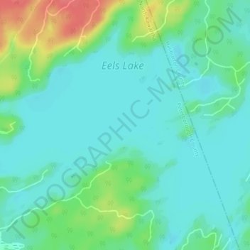
Name: Eels Lake topographic map, elevation, terrain.
Average elevation: 361 m
Minimum elevation: 345 m
Maximum elevation: 407 m
Peterborough County trails, hiking, mountain biking, running and outdoor activities
Other topographic maps
Click on a map to view its topography, its elevation and its terrain.
Kawartha Highlands Provincial Park
Canada > Ontario > Peterborough County > North Kawartha
Average elevation: 306 m
Trent-Severn Waterway
Canada > Ontario > Peterborough County > North Kawartha > Burleigh Falls
Average elevation: 249 m
Stony Lake
Canada > Ontario > Peterborough County > North Kawartha > Burleigh Falls
Average elevation: 255 m