Geolocate

Spruce Grove topographic map

Click on the map to display elevation.

About this map

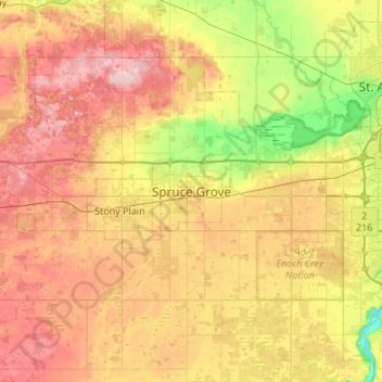
Name: Spruce Grove topographic map, elevation, terrain.

Location: Spruce Grove, Alberta, T7X 2Z7, Canada (53.38520 -114.06350 53.70520 -113.74350)

Average elevation: 709 m

Minimum elevation: 623 m

Maximum elevation: 805 m

Alberta trails, hiking, mountain biking, running and outdoor activities

Gear up for your next adventure:

🪑Insulated Seat Pad - Protect your seat from cold rocks and wet logs
🛰️Satellite Messenger - Emergency communication for areas with no cell service
💧Filtered Water Bottle - Safe drinking water on the go
Backpacking Tent - Lightweight tent for long-distance hiking trips
👖Convertible Hiking Pants - Zip-off legs to adapt to changing weather conditions

As an Amazon Associate, this site earns from qualifying purchases at no extra cost to you.