
Ecuador topographic map
Interactive map
Click on the map to display elevation.
Ecuador
There is great variety in the climate, largely determined by altitude. It is mild year-round in the mountain valleys, with a humid subtropical climate in coastal areas and rainforest in lowlands. The Pacific coastal area has a tropical climate with a severe rainy season. The climate in the Andean highlands is temperate and relatively dry, and the Amazon basin on the eastern side of the mountains shares the climate of other rainforest zones.
About this map
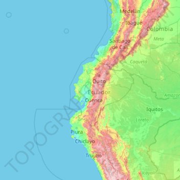
Name: Ecuador topographic map, elevation, terrain.
Location: Ecuador (-5.01593 -92.20724 1.88360 -75.19250)
Average elevation: 366 m
Minimum elevation: -3 m
Maximum elevation: 5,762 m
Other topographic maps
Click on a map to view its topography, its elevation and its terrain.
Vancouver
Canada > British Columbia > Metro Vancouver Regional District
Winters in Greater Vancouver are the fourth-mildest of Canadian cities after nearby Victoria, Nanaimo and Duncan, all on Vancouver Island. Vancouver's growing season averages 237 days, from March 18 until November 10. Vancouver's 1981–2010 USDA Plant Hardiness Zone ranges from 8A to 9A depending on elevation…
Average elevation: 34 m
Ontario
Despite the absence of any mountainous terrain in the province, there are large areas of uplands, particularly within the Canadian Shield which traverses the province from northwest to southeast and also above the Niagara Escarpment which crosses the south. The highest point is Ishpatina Ridge at 693 metres…
Average elevation: 245 m
British Columbia
The Southern Interior cities of Kamloops and Penticton have some of the warmest and longest summer climates in Canada (while higher elevations are cold and snowy), although their temperatures are often exceeded north of the Fraser Canyon, close to the confluence of the Fraser and Thompson rivers, where the…
Average elevation: 708 m
Canada
Average elevation: 254 m
Township of Langley
Canada > British Columbia > Metro Vancouver Regional District
Average elevation: 47 m
Calgary
Calgary experiences a semi-monsoonal humid continental climate (Köppen climate classification Dwb) within eastern parts of the city and a subarctic climate (Köppen climate classification Dwc) within western parts of the city due to an increase in elevation. The city has warm, comfortable summers and…
Average elevation: 1,106 m
Toronto
Despite its deep ravines, Toronto is not remarkably hilly, but its elevation does increase steadily away from the lake. Elevation differences range from 76.5 metres (251 ft) above sea level at the Lake Ontario shore to 209 m (686 ft) ASL near the York University grounds in the city's north end at the…
Average elevation: 113 m
Winnipeg
Winnipeg lies at the bottom of the Red River Valley, a flood plain with an extremely flat topography. It is on the eastern edge of the Canadian Prairies in Western Canada and is known as the "Gateway to the West". Winnipeg is bordered by tallgrass prairie to the west and south and the aspen parkland to the…
Average elevation: 236 m
Coquitlam
Canada > British Columbia > Metro Vancouver Regional District
Like much of Metro Vancouver, Coquitlam has an oceanic climate (Köppen climate type Cfb), experiencing mild temperatures and high precipitation; warm, dry summers and cool, wet winters. However, compared to most other cities in the area, precipitation is especially heavy in Coquitlam due to its proximity to…
Average elevation: 190 m
Burnaby
Canada > British Columbia > Metro Vancouver Regional District > Burnaby
Burnaby occupies 98.60 square kilometres (38.07 sq mi) and is located at the geographic centre of the Metro Vancouver area and home to the Metro Vancouver regional government in Metrotown. Situated between the city of Vancouver on the west and Port Moody, Coquitlam, and New Westminster on the east, Burnaby is…
Average elevation: 144 m
Bothell
United States > Washington > King County
Other events are hosted by community organizations, such as the annual Bothell block party and brewfest sponsored by University of Washington Bothell and the local chamber of commerce. The annual "Sustainamania" has been held in Bothell since 2012 to promote sustainable living, conservation, and education. A…
Average elevation: 68 m
Pinellas County
Elevation in the county ranges from mean sea level to its highest natural point of 110 feet (34 m) near the intersection of SR 580 and Countryside Blvd. in Clearwater. Due to its small size and high population, by the early 21st century Pinellas County has been mostly built out, with very little developable…
Average elevation: 4 m
Burnaby
Canada > British Columbia > Metro Vancouver Regional District
Burnaby occupies 98.6 square kilometres (38.1 sq mi) and is located at the geographic centre of the Metro Vancouver Regional District. The regional district's government is located in Burnaby's Metrotown area. Situated between the city of Vancouver on the west and Port Moody, Coquitlam, and New Westminster on…
Average elevation: 59 m
Guelph
This region of Ontario has cold winters and warm, humid summers, falling into the Köppen climate classification Dfb zone, with moderately high rainfall and snowfall. It is generally a couple of degrees cooler than lower elevation regions on the Great Lakes shorelines, especially so in winter, the exception…
Average elevation: 344 m
Maryland
Sixteen of Maryland's twenty-three counties, as well as the city of Baltimore, border the tidal waters of the Chesapeake Bay estuary and its many tributaries, which combined total more than 4,000 miles of shoreline. Although one of the smallest states in the U.S., it features a variety of climates and…
Average elevation: 149 m
Quebec
Quebec's topography is very different from one region to another due to the varying composition of the ground, the climate, and the proximity to water. More than 95% of Quebec's territory, including the Labrador Peninsula, lies within the Canadian Shield. It is generally a quite flat and exposed mountainous…
Average elevation: 195 m
Upper Peninsula
Including extensive parts of the Great Lakes, the Upper Peninsula contains about 36,139 square miles (93,600 km2) of total area. Of that, about 16,378 square miles (42,420 km2) is its land area, about 29% of the state. It is bounded on the north by Lake Superior, on the east by St. Marys River, on the south by…
Average elevation: 274 m
Vancouver Island
The rain shadow effect of the island's mountains, as well as the mountains of Washington's Olympic Peninsula, creates wide variation in precipitation. The west coast is considerably wetter than the east coast. Average annual precipitation ranges from 6,650 mm (262 in) at Hucuktlis Lake on the west coast…
Average elevation: 411 m
Tacoma
United States > Washington > Pierce County
Tacoma is at 47°14′29″N 122°27′34″W / 47.24139°N 122.45944°W / 47.24139; -122.45944 (47.241371, −122.459389). Its official elevation is 381 feet (116 m), varying between sea level and about 500 feet (150 m).
Average elevation: 67 m
Newfoundland and Labrador
In 1496, John Cabot obtained a charter from English King Henry VII to "sail to all parts, countries and seas of the East, the West and of the North, under our banner and ensign and to set up our banner on any new-found-land" and on June 24, 1497, landed in Cape Bonavista. Historians disagree on whether Cabot…
Average elevation: 192 m
Galveston
United States > Texas > Galveston County
On September 8, 1900, the island was struck by a devastating hurricane. This event holds the record as the United States' deadliest natural disaster. The city was devastated, and an estimated 6,000 to 8,000 people on the island were killed. Following the storm, a 10-mile (16 km) long, 17 foot (5.2 m) high…
Average elevation: 1 m
Mission
Canada > British Columbia > Fraser Valley Regional District
The western part of the district, the Stave Valley, is largely rural and forested but its watercourse is home to what was the largest hydroelectric project in British Columbia until the Bridge River Power Project opened in 1961. It was built by the British Columbia Electric Railway (BCER) to provide power to…
Average elevation: 345 m
Kelowna
Canada > British Columbia > Regional District of Central Okanagan
Kelowna is classified as a humid continental climate or an inland oceanic climate per the Köppen climate classification system due to its coldest month having an average temperature slightly above −3.0 °C (26.6 °F) and below 0 °C (32 °F), with dry, hot, sunny summers and cool, cloudy winters, and four…
Average elevation: 704 m
Halifax
Canada > Nova Scotia > Halifax County
The coastline is heavily indented, accounting for its length of approximately 400 km (250 mi), with the northern boundary of the municipality usually being between 50–60 km (31–37 mi) inland. The coast is mostly rock with small isolated sand beaches in sheltered bays. The largest coastal features include…
Average elevation: 46 m
Edmonton
Edmonton is on the North Saskatchewan River, at an elevation of 671 m (2,201 ft). It is North America's northernmost city with a metropolitan population over one million. It is at the same latitude as Hamburg (Germany); Dublin (Ireland); Manchester (United Kingdom); and Magnitogorsk (Russia). It is south of…
Average elevation: 690 m
Tsawwassen
Canada > British Columbia > Metro Vancouver Regional District > Delta
Average elevation: 12 m
Lubbock
United States > Texas > Lubbock County
Summers are hot, with 78 afternoons on average of 90 °F (32.2 °C)+ highs and 7.4 afternoons of 100 °F (37.8 °C)+ highs, although due to the aridity and elevation, temperatures remain above 70 °F (21.1 °C) on only a few mornings. Lubbock is the 10th-windiest city in the US with an average wind speed of…
Average elevation: 983 m
Sandy
United States > Oregon > Clackamas County
According to the United States Census Bureau, the city has a total area of 3.14 square miles (8.13 km2), consisting almost entirely of land. Its elevation is 967 feet (295 m).
Average elevation: 247 m
London
Canada > Ontario > London > London
London has a humid continental climate (Köppen Dfb), though due to its downwind location relative to Lake Huron and elevation changes across the city, it is virtually on the Dfa/Dfb (hot summer) boundary favouring the former climate zone to the southwest of the confluence of the South and North Thames Rivers,…
Average elevation: 268 m
Seattle
United States > Washington > King County
The city itself is hilly, though not uniformly so. Like Rome, the city is said to lie on seven hills; the lists vary but typically include Capitol Hill, First Hill, West Seattle, Beacon Hill, Queen Anne, Magnolia, and the former Denny Hill. The Wallingford, Delridge, Mount Baker, Seward Park, Washington Park,…
Average elevation: 40 m
St. Catharines
Canada > Ontario > Niagara Region
The most defining transportation icon of St. Catharines is the Welland Canal, a ship canal that runs 43.4 kilometres (27.0 mi), passing through the city. Four of its locks are within city boundaries. The canal allows shipping vessels to traverse the 99.5-metre (326.5 ft) drop in altitude from Lake Erie to Lake…
Average elevation: 103 m
Mississauga
Canada > Ontario > Peel Region
The shoreline of former Glacial Lake Iroquois roughly follows the Dundas Street alignment, although it is not noticeable in some places but is more prominent in others, such as the site of the former brickyard (Shoreline Dr. near Mavis Rd.), the ancient shoreline promenteau affords a clear view of downtown…
Average elevation: 151 m
Fort McMurray
Canada > Alberta > Wood Buffalo
The community lies at a lower elevation than most other parts of Alberta, so under the right conditions it can be a "hot spot" for Alberta.
Average elevation: 345 m
Palmdale
United States > California > Los Angeles County
Downtown Palmdale is located at 34°34′46″N 118°07′00″W / 34.57944°N 118.11667°W / 34.57944; -118.11667, at an elevation of 2,655 feet (809 m) above sea level.
Average elevation: 898 m
Coquitlam
Canada > British Columbia > Metro Vancouver Regional District > Coquitlam
Southwest Coquitlam comprises the original core of the city, with Maillardville and Fraser River industrial sector giving way to the large residential areas of Austin Heights, colloquially referred to as "The Bump" due to its high and flat plateau topography. These older residences, with larger property…
Average elevation: 230 m
Caribbean
Rainfall varies with elevation, size and water currents, such as the cool upwellings that keep the ABC islands arid. Warm, moist trade winds blow consistently from the east, creating both rain forest and semi arid climates across the region. The tropical rainforest climates include lowland areas near the…
Average elevation: 20 m
Chico
United States > California > Butte County
An altitude record for unmanned gas balloons was set in Chico in October 1972 (51.8 km or 32.2 mi). The record was broken on May 23, 2002.
Average elevation: 95 m
Palm Desert
United States > California > Riverside County
The elevation (City hall) is 224 feet (68 m) above sea level. Elevations vary from the lower northern half once covered in sand dunes to the upper slope southern cove (300–900 feet or 91–274 metres) all the way to the ridgeline at 1,000 feet (300 m). Palm Desert is located in the Coachella Valley, the…
Average elevation: 178 m
District of North Vancouver
Canada > British Columbia > Metro Vancouver Regional District
Average elevation: 358 m
Silver City
United States > New Mexico > Grant County
During the period from 1901 to 1964, when readings were taken at the city center (which is cooler and wetter than outlying and lower-elevation districts nearby), the coldest temperature recorded was −13 °F (−25 °C) on January 11, 1962, and the hottest 105 °F (40.6 °C) on July 5, 1901. The coldest month…
Average elevation: 1,851 m
Mojmírovce
Slovakia > Region of Nitra > District of Nitra
The village lies at an altitude of 140 metres and covers an area of 19.863 km². It has a population of about 2740 people.
Average elevation: 147 m
Gimmelwald
Switzerland > Bern > Interlaken-Oberhasli administrative district
Average elevation: 1,564 m
Genoa
The city of Genoa covers an area of 243 square kilometres (94 sq mi) between the Ligurian Sea and the Apennine Mountains. The city stretches along the coast for about 30 kilometres (19 mi) from the neighbourhood of Voltri to Nervi, and for 10 kilometres (6.2 mi) from the coast to the north along the valleys…
Average elevation: 333 m
Langley Township
Canada > British Columbia > Metro Vancouver Regional District > Township of Langley > Langley Township
Average elevation: 37 m