
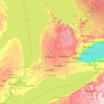
Southwestern Ontario topographic map
Interactive map
Click on the map to display elevation.
About this map
Name: Southwestern Ontario topographic map, elevation, terrain.
Location: Southwestern Ontario, Canada (41.67656 -83.14969 45.36223 -79.29661)
Average elevation: 235 m
Minimum elevation: 72 m
Maximum elevation: 719 m
Other topographic maps
Click on a map to view its topography, its elevation and its terrain.
Vancouver
Canada > British Columbia > Metro Vancouver Regional District
Vancouver, Metro Vancouver Regional District, British Columbia, Canada
Average elevation: 34 m
Burnaby
Canada > British Columbia > Metro Vancouver Regional District
Burnaby, Metro Vancouver Regional District, British Columbia, Canada
Average elevation: 59 m
Edmonton
Canada > Alberta > Division No. 11
Edmonton, Division No. 11, Alberta, Canada
Average elevation: 690 m
Victoria
Canada > British Columbia > Capital Regional District
Victoria, Capital Regional District, British Columbia, Canada
Average elevation: 17 m
Burlington
Canada > Ontario > Halton Region
Burlington, Halton Region, Golden Horseshoe, Ontario, Canada
Average elevation: 141 m
Vancouver Island
Vancouver Island, British Columbia, Canada
Average elevation: 411 m
Halifax
Canada > Nova Scotia > Halifax County
Halifax, Halifax Regional Municipality, Halifax County, Nova Scotia, Canada
Average elevation: 46 m
Kitchener
Canada > Ontario > Region of Waterloo
Kitchener, Region of Waterloo, Ontario, Canada
Average elevation: 336 m
Jasper National Park
Jasper National Park, Alberta, T0E 1E0, Canada
Average elevation: 1,782 m
Township of Langley
Canada > British Columbia > Metro Vancouver Regional District
Township of Langley, Metro Vancouver Regional District, British Columbia, Canada
Average elevation: 47 m
Durham Region
Durham Region, Golden Horseshoe, Ontario, Canada
Average elevation: 235 m
Montreal
Canada > Quebec > Urban agglomeration of Montreal
Montreal, Urban agglomeration of Montreal, Montreal (administrative region), Quebec, Canada
Average elevation: 29 m
Metro Vancouver Regional District
Metro Vancouver Regional District, British Columbia, Canada
Average elevation: 343 m
Quebec
Canada > Quebec > Urban agglomeration of Québec
Quebec, Urban agglomeration of Québec, Capitale-Nationale, Quebec, Canada
Average elevation: 117 m
Kelowna
Canada > British Columbia > Regional District of Central Okanagan
Kelowna, Regional District of Central Okanagan, British Columbia, Canada
Average elevation: 704 m
Cape Breton Island
Cape Breton Island, Nova Scotia, Canada
Average elevation: 66 m
Sooke
Canada > British Columbia > Capital Regional District
Sooke, Capital Regional District, British Columbia, Canada
Average elevation: 206 m
Nose Hill Park
Nose Hill Park, Calgary, Alberta, T3K 2P6, Canada
Average elevation: 1,174 m
Sir Winston Churchill Park
Canada > Ontario > Old Toronto
Sir Winston Churchill Park, Toronto—St. Paul's, Old Toronto, Toronto, Golden Horseshoe, Ontario, Canada
Average elevation: 145 m
Surrey
Canada > British Columbia > Metro Vancouver Regional District
Surrey, Metro Vancouver Regional District, British Columbia, Canada
Average elevation: 28 m
Scarborough
Scarborough, Toronto, Golden Horseshoe, Ontario, Canada
Average elevation: 138 m
Niagara Region
Niagara Region, Golden Horseshoe, Ontario, Canada
Average elevation: 148 m
Côte-du-Lac
Canada > Quebec > Urban agglomeration of Québec > Quebec
Côte-du-Lac, Laurentides, Beauport, Quebec, Urban agglomeration of Québec, Capitale-Nationale, Quebec, G1B 2E2, Canada
Average elevation: 251 m
Saltspring Island
Canada > British Columbia > Capital Regional District > Salt Spring Island Electoral Area
Saltspring Island, Salt Spring Island Electoral Area, Capital Regional District, British Columbia, Canada
Average elevation: 72 m
Nanaimo
Canada > British Columbia > Regional District of Nanaimo
Nanaimo, Regional District of Nanaimo, British Columbia, Canada
Average elevation: 110 m
North Vancouver
Canada > British Columbia > North Vancouver
North Vancouver, Metro Vancouver Regional District, British Columbia, V7M 1H9, Canada
Average elevation: 258 m
Chilliwack
Canada > British Columbia > Fraser Valley Regional District
Chilliwack, Fraser Valley Regional District, British Columbia, Canada
Average elevation: 240 m
Campbell River
Canada > British Columbia > Strathcona Regional District
Campbell River, Strathcona Regional District, British Columbia, Canada
Average elevation: 70 m
Katepwa Lake
Canada > Saskatchewan > Division No. 6 > Katepwa
Katepwa Lake, Katepwa, Division No. 6, Saskatchewan, Canada
Average elevation: 536 m
Ottawa River
Canada > Ontario > Ottawa > Pontiac
Ottawa River, Université Private, Sandy Hill, Rideau-Vanier, (Old) Ottawa, Ottawa, Eastern Ontario, Ontario, K1N 9A5, Canada
Average elevation: 318 m
Maple Ridge
Canada > British Columbia > Maple Ridge
Maple Ridge, Metro Vancouver Regional District, British Columbia, V2X 6G2, Canada
Average elevation: 193 m
Abbotsford
Canada > British Columbia > Fraser Valley Regional District
Abbotsford, Fraser Valley Regional District, British Columbia, Canada
Average elevation: 99 m
100 Mile House
Canada > British Columbia > Cariboo Regional District
100 Mile House, Cariboo Regional District, British Columbia, Canada
Average elevation: 1,047 m