
Make a donation
Gear up for your next adventure:
As an Amazon Associate, this site earns from qualifying purchases at no extra cost to you.
Vancouver Island topographic map
Click on the map to display elevation.
Make a donation
Gear up for your next adventure:
As an Amazon Associate, this site earns from qualifying purchases at no extra cost to you.
Vancouver Island
The rain shadow effect of the island's mountains, as well as the mountains of Washington's Olympic Peninsula, creates wide variation in precipitation. The west coast is considerably wetter than the east coast. Average annual precipitation ranges from 6,650 mm (262 in) at Hucuktlis Lake on the west coast (making it the wettest place in North America) to only 608 mm (23.9 in) at Victoria Gonzales, the driest recording station in the provincial capital of Victoria. Precipitation is heaviest in the autumn and winter. Snow is rare at low altitudes, but is common on the island's mountaintops in winter. Skiing is popular at Mount Washington in the mid-island, with an elevation of 1,588 m (5,210 ft).
Make a donation
Gear up for your next adventure:
As an Amazon Associate, this site earns from qualifying purchases at no extra cost to you.
About this map
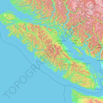
Name: Vancouver Island topographic map, elevation, terrain.
Location: Vancouver Island, British Columbia, Canada (48.30888 -128.43292 50.87683 -123.26478)
Average elevation: 411 m
Minimum elevation: -3 m
Maximum elevation: 3,169 m
British Columbia trails, hiking, mountain biking, running and outdoor activities
Make a donation
Gear up for your next adventure:
As an Amazon Associate, this site earns from qualifying purchases at no extra cost to you.
Other topographic maps
Click on a map to view its topography, its elevation and its terrain.
Nanoose Bay
Canada > British Columbia > Regional District of Nanaimo > Area E (Nanoose Bay)
Average elevation: 58 m
Manning Park
Canada > British Columbia > Regional District of Okanagan-Similkameen > Area H (Manning Park/Tulameen/Siwash)
Average elevation: 1,420 m
Make a donation
Gear up for your next adventure:
As an Amazon Associate, this site earns from qualifying purchases at no extra cost to you.
Willow River
Canada > British Columbia > Regional District of Fraser-Fort George > Area F (Willow River/Upper Fraser)
Average elevation: 621 m
Spider Lake
Canada > British Columbia > Thompson-Nicola Regional District > Area O (Lower North Thompson)
Average elevation: 1,358 m
Make a donation
Gear up for your next adventure:
As an Amazon Associate, this site earns from qualifying purchases at no extra cost to you.
Burnaby
Canada > British Columbia > Metro Vancouver Regional District > Burnaby
Burnaby occupies 98.60 square kilometres (38.07 sq mi) and is located at the geographic centre of the Metro Vancouver area and home to the Metro Vancouver regional government in Metrotown. Situated between the city of Vancouver on the west and Port Moody, Coquitlam, and New Westminster on the east, Burnaby is…
Average elevation: 144 m
Salmon Arm
Canada > British Columbia > Columbia-Shuswap Regional District > Salmon Arm > Salmon Arm
Average elevation: 479 m
Kamloops
Canada > British Columbia > Thompson-Nicola Regional District > Kamloops
Average elevation: 875 m
Bleeker Lake
Canada > British Columbia > Thompson-Nicola Regional District > Area L (Grasslands)
Average elevation: 1,148 m
Make a donation
Gear up for your next adventure:
As an Amazon Associate, this site earns from qualifying purchases at no extra cost to you.
Cobble Hill
Canada > British Columbia > Cowichan Valley Regional District > Area C (Cobble Hill)
Average elevation: 116 m
Christina Lake
Canada > British Columbia > Regional District of Kootenay Boundary > Area C (Christina Lake)
Average elevation: 588 m
Make a donation
Gear up for your next adventure:
As an Amazon Associate, this site earns from qualifying purchases at no extra cost to you.
Burnaby Mountain
Canada > British Columbia > Metro Vancouver Regional District > Burnaby
Due to its relatively high elevation, snow will often fall on the higher levels of Burnaby Mountain while rain falls in the surrounding cities. Tobogganing is a popular pastime at Centennial Park on winter days with snow.
Average elevation: 167 m
Bralorne
Canada > British Columbia > Squamish-Lillooet Regional District > Area A (Upper Bridge River Valley)
Average elevation: 1,255 m
Anahim Lake
Canada > British Columbia > Cariboo Regional District > Area J (West Chilcotin)
Average elevation: 1,101 m
Make a donation
Gear up for your next adventure:
As an Amazon Associate, this site earns from qualifying purchases at no extra cost to you.
Rosedale
Canada > British Columbia > Fraser Valley Regional District > Chilliwack
Average elevation: 23 m
Fernie
Canada > British Columbia > Regional District of East Kootenay > Fernie
Average elevation: 1,551 m
Yale
Canada > British Columbia > Fraser Valley Regional District > Area B (South Fraser Canyon/Sunshine Valley)
Average elevation: 340 m
Hope Slide
Canada > British Columbia > Fraser Valley Regional District > Area B (South Fraser Canyon/Sunshine Valley)
Average elevation: 1,160 m
Make a donation
Gear up for your next adventure:
As an Amazon Associate, this site earns from qualifying purchases at no extra cost to you.
Make a donation
Gear up for your next adventure:
As an Amazon Associate, this site earns from qualifying purchases at no extra cost to you.
Coast Mountains
Canada > British Columbia > Area A (Seymour Inlet/Knight Inlet)
The Coast Mountains are part of the Pacific Ring of Fire—the ring of volcanoes and associated mountains around the Pacific Ocean—and contain some of British Columbia's highest mountains. Mount Waddington is the highest mountain of the Coast Mountains and the highest that lies entirely within British…
Average elevation: 1,951 m
Make a donation
Gear up for your next adventure:
As an Amazon Associate, this site earns from qualifying purchases at no extra cost to you.
Pavilion
The early anglicized version of the village name was Skwailuk, meaning hoar-frost, perhaps indicating the shaded ground remaining frozen during the long winters at this elevation. The Ts'kw'aylaxw First Nation (a.k.a. the Tsk'waylacw First Nation or Tsk'weylecw First Nation), residing on the Pavilion 1 Indian…
Average elevation: 855 m
Saanich Peninsula
Canada > British Columbia > Capital Regional District > Central Saanich
Average elevation: 49 m
Make a donation
Gear up for your next adventure:
As an Amazon Associate, this site earns from qualifying purchases at no extra cost to you.
Make a donation
Gear up for your next adventure:
As an Amazon Associate, this site earns from qualifying purchases at no extra cost to you.
English Bay Beach
Canada > British Columbia > Metro Vancouver Regional District > Vancouver
Average elevation: 12 m
Make a donation
Gear up for your next adventure:
As an Amazon Associate, this site earns from qualifying purchases at no extra cost to you.
Make a donation
Gear up for your next adventure:
As an Amazon Associate, this site earns from qualifying purchases at no extra cost to you.
Mill Bay
Canada > British Columbia > Cowichan Valley Regional District > Area A (Mill Bay / Malahat)
Average elevation: 61 m
Shawnigan Lake
Canada > British Columbia > Cowichan Valley Regional District > Area B (Shawnigan Lake)
Average elevation: 128 m
Scotch Creek
Canada > British Columbia > Columbia-Shuswap Regional District > Area F (Scotch Creek/Seymour Arm)
Average elevation: 1,125 m
Anglemont
Canada > British Columbia > Columbia-Shuswap Regional District > Area F (Scotch Creek/Seymour Arm)
Average elevation: 472 m
Make a donation
Gear up for your next adventure:
As an Amazon Associate, this site earns from qualifying purchases at no extra cost to you.
Fort Steele
Canada > British Columbia > Regional District of East Kootenay > Area C (Moyie/Bull River)
Average elevation: 797 m
Bamfield
Canada > British Columbia > Alberni-Clayoquot Regional District > Area A (Bamfield)
Average elevation: 16 m
Make a donation
Gear up for your next adventure:
As an Amazon Associate, this site earns from qualifying purchases at no extra cost to you.
Fording River
Canada > British Columbia > Regional District of East Kootenay > Elkford
Average elevation: 1,787 m
Christian Valley
Canada > British Columbia > Regional District of Kootenay Boundary > Area E (Beaverdell/West Boundary)
Average elevation: 917 m
Mara Lake
Canada > British Columbia > Columbia-Shuswap Regional District > Area E (Eagle River Valley) > Swansea Point
The lake is 35.3 kilometres (21.9 mi) long. The surface area is about 1,943 hectares (4,800 acres) and elevation is 338 metres (1,109 ft) above sea level. The mean and maximum depth is 18 metres (59 ft).
Average elevation: 826 m
Langley Township
Canada > British Columbia > Metro Vancouver Regional District > Township of Langley > Langley Township
Average elevation: 37 m
Make a donation
Gear up for your next adventure:
As an Amazon Associate, this site earns from qualifying purchases at no extra cost to you.
Kingsgate
Canada > British Columbia > Regional District of Central Kootenay > Area B (Goat River Valley)
Average elevation: 979 m
Extension
Canada > British Columbia > Regional District of Nanaimo > Area C (Arrowsmith-Benson)
Average elevation: 175 m
Royston
Canada > British Columbia > Comox Valley Regional District > Area A (Baynes Sound)
Average elevation: 29 m
Make a donation
Gear up for your next adventure:
As an Amazon Associate, this site earns from qualifying purchases at no extra cost to you.
Abbotsford
Canada > British Columbia > Fraser Valley Regional District > Abbotsford
Average elevation: 115 m
Mundy Park
Canada > British Columbia > Metro Vancouver Regional District > Coquitlam
Average elevation: 139 m
Fraser River (North Arm)
Canada > British Columbia > Metro Vancouver Regional District > Richmond
Average elevation: 27 m
Garibaldi
Canada > British Columbia > Squamish-Lillooet Regional District > Area D (Elaho/Garibaldi)
Average elevation: 417 m
Make a donation
Gear up for your next adventure:
As an Amazon Associate, this site earns from qualifying purchases at no extra cost to you.
Hansard Lake
Canada > British Columbia > Regional District of Fraser-Fort George > Area F (Willow River/Upper Fraser)
Average elevation: 639 m
Gold Bridge
Canada > British Columbia > Squamish-Lillooet Regional District > Area A (Upper Bridge River Valley)
Average elevation: 886 m
Mike Lake
Canada > British Columbia > Metro Vancouver Regional District > Maple Ridge
Average elevation: 297 m
Bouchie Lake
Canada > British Columbia > Cariboo Regional District > Area B (Quesnel West/Bouchie Lake)
Average elevation: 699 m
Make a donation
Gear up for your next adventure:
As an Amazon Associate, this site earns from qualifying purchases at no extra cost to you.
Woss
Canada > British Columbia > Regional District of Mount Waddington > Area D (Nimpkish Valley/Cormorant Island)
Average elevation: 200 m
Oyster River
Canada > British Columbia > Strathcona Regional District > Area D (Oyster Bay/Buttle Lake) > Oyster River
Average elevation: 24 m
Shuswap
Canada > British Columbia > Regional District of East Kootenay > Area F (Columbia Lake/Windermere Lake)
Average elevation: 926 m
Make a donation
Gear up for your next adventure:
As an Amazon Associate, this site earns from qualifying purchases at no extra cost to you.
Gabriola
Canada > British Columbia > Regional District of Nanaimo > Area B (DeCourcy/Gabriola/Mudge)
Gabriola is about 14 kilometres (9 mi) long by 4.2 kilometres (2.6 mi) wide on average with a land area of 57.6 square kilometres (22.2 sq mi). The topography varies from flat sandy beaches at sea level to forested hills rising to 160 metres (525 ft) on Stoney Ridge in the centre of the island.
Average elevation: 31 m
Errington
Canada > British Columbia > Regional District of Nanaimo > Area F (Alberni Highway)
Average elevation: 120 m
The Commons Field
Canada > British Columbia > Regional District of Central Okanagan > Kelowna
Average elevation: 442 m
Woodlot 0007
Canada > British Columbia > Metro Vancouver Regional District > Maple Ridge
Average elevation: 322 m
Make a donation
Gear up for your next adventure:
As an Amazon Associate, this site earns from qualifying purchases at no extra cost to you.
Agur Lake
Canada > British Columbia > Regional District of Okanagan-Similkameen > Area F (Trout Creek Valley)
Average elevation: 1,178 m
Faulder
Canada > British Columbia > Regional District of Okanagan-Similkameen > Area F (Trout Creek Valley)
Average elevation: 850 m
Crooked River
Canada > British Columbia > Regional District of Fraser-Fort George > Area G (Crooked River/Parsnip)
Average elevation: 749 m
Carp Lake
Canada > British Columbia > Regional District of Fraser-Fort George > Area G (Crooked River/Parsnip)
Average elevation: 865 m
Make a donation
Gear up for your next adventure:
As an Amazon Associate, this site earns from qualifying purchases at no extra cost to you.
Pine River
Canada > British Columbia > Peace River Regional District > Area E (Moberly Lake/Sukunka Valley)
Average elevation: 973 m
Parkland
Canada > British Columbia > Peace River Regional District > Area D (Kiskatinaw Valley)
Average elevation: 726 m
Walnut Park
Canada > British Columbia > Metro Vancouver Regional District > Surrey
Average elevation: 49 m
Make a donation
Gear up for your next adventure:
As an Amazon Associate, this site earns from qualifying purchases at no extra cost to you.
Mount Tabor
Canada > British Columbia > Regional District of Fraser-Fort George > Area D (Tabor Lake/Stone Creek)
Average elevation: 1,119 m
Cottonwood River
Canada > British Columbia > Cariboo Regional District > Area C (Bowron Lake/Barlow Creek/Barkerville)
Average elevation: 799 m
Harrison River
Canada > British Columbia > Fraser Valley Regional District > Kent > Harrison Mills
Average elevation: 45 m
Horse Lake
Canada > British Columbia > Cariboo Regional District > Area K (East Chilcotin)
Average elevation: 1,938 m
Make a donation
Gear up for your next adventure:
As an Amazon Associate, this site earns from qualifying purchases at no extra cost to you.
Stoney Hill
Canada > British Columbia > Cowichan Valley Regional District > North Cowichan
Average elevation: 78 m
Elk Falls Viewing Platform
Canada > British Columbia > Strathcona Regional District > Campbell River
Average elevation: 137 m
Lake O'Hara
Canada > British Columbia > Columbia-Shuswap Regional District > Area A (Kicking Horse/Kinbasket Lake)
Lake O'Hara is a lake at an elevation of 2,020 metres (6,630 ft) in the alpine area of Yoho National Park, in the province of British Columbia, on the western side of the Great Divide with the province of Alberta and Banff National Park to the east. The lake and the valley are accessible through a bus service…
Average elevation: 2,276 m
Kootenay Columbia
Canada > British Columbia > Regional District of Kootenay Boundary > Area B (Lower Columbia/Old Glory)
Average elevation: 1,013 m
Make a donation
Gear up for your next adventure:
As an Amazon Associate, this site earns from qualifying purchases at no extra cost to you.
Wardner
Canada > British Columbia > Regional District of East Kootenay > Area C (Moyie/Bull River)
Average elevation: 815 m
Fintry
Canada > British Columbia > Regional District of Central Okanagan > West Central Okanagan Electoral Area
Average elevation: 437 m
Goat River
Canada > British Columbia > Regional District of Central Kootenay > Area B (Goat River Valley)
Average elevation: 1,713 m
Sumas River
Canada > British Columbia > Fraser Valley Regional District > Abbotsford
Average elevation: 167 m
Make a donation
Gear up for your next adventure:
As an Amazon Associate, this site earns from qualifying purchases at no extra cost to you.