Calgary topographic map
Interactive map
Click on the map to display elevation.
About this map
![Calgary topographic map, elevation, terrain](/pub/maps/relation/8d51/wnq557/thumbnail.jpg)
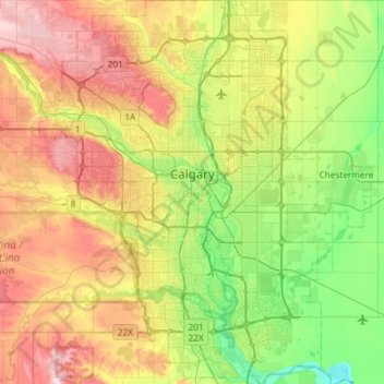
Name: Calgary topographic map, elevation, terrain.
Location: Calgary, Alberta, Canada (50.84253 -114.31576 51.21250 -113.86000)
Average elevation: 1,106 m
Minimum elevation: 957 m
Maximum elevation: 1,349 m
Calgary experiences a semi-monsoonal humid continental climate (Köppen climate classification Dwb) within eastern parts of the city and a subarctic climate (Köppen climate classification Dwc) within western parts of the city due to an increase in elevation. The city has warm, comfortable summers and freezing, dry (but like all of Alberta extremely variable) winters. It falls into the NRC Plant Hardiness Zone 4a. According to Environment Canada, average daily temperatures in Calgary range from 16.5 °C (61.7 °F) in July to −7.1 °C (19.2 °F) in January.
Other topographic maps
Click on a map to view its topography, its elevation and its terrain.
![Edmonton topographic map, elevation, terrain](/pub/maps/relation/kbkl/2614cz/icon.jpg)
Edmonton
Canada > Alberta > Division No. 11
Edmonton, Division No. 11, Alberta, Canada
Average elevation: 690 m
![Jasper National Park topographic map, elevation, terrain](/pub/maps/relation/kp4s/bdx3tf/icon.jpg)
Jasper National Park
Jasper National Park, Alberta, T0E 1E0, Canada
Average elevation: 1,782 m
![Cochrane topographic map, elevation, terrain](/pub/maps/node/gs57/t6pltdn/icon.jpg)
Cochrane
Canada > Alberta > Town of Cochrane > Cochrane
Cochrane, Town of Cochrane, Alberta, T4V 2A7, Canada
Average elevation: 1,205 m
![Nose Hill Park topographic map, elevation, terrain](/pub/maps/way/9tb3/3wmmgt/icon.jpg)
Nose Hill Park
Nose Hill Park, Calgary, Alberta, T3K 2P6, Canada
Average elevation: 1,174 m
![Waterton Lakes National Park topographic map, elevation, terrain](/pub/maps/relation/lw1h/7mfjz4/icon.jpg)
Waterton Lakes National Park
Canada > Alberta > Division No. 3
Waterton Lakes National Park, Division No. 3, Alberta, Canada
Average elevation: 1,778 m
![Lethbridge topographic map, elevation, terrain](/pub/maps/node/wqtf/d6xm2ks8/icon.jpg)
Lethbridge
Canada > Alberta > Lethbridge
Lethbridge, City of Lethbridge, Alberta, T1J 4L3, Canada
Average elevation: 918 m
![Tall Cree 173 topographic map, elevation, terrain](/pub/maps/relation/l41h/b1cjmt/icon.jpg)
Tall Cree 173
Canada > Alberta > Mackenzie County > South Tallcree
Tall Cree 173, South Tallcree, Mackenzie County, Alberta, Canada
Average elevation: 336 m
![Grande Prairie topographic map, elevation, terrain](/pub/maps/node/h8cz/92qt83t6/icon.jpg)
Grande Prairie
Canada > Alberta > Grande Prairie
Grande Prairie, City of Grande Prairie, Alberta, T8V 2X3, Canada
Average elevation: 668 m
![Kananaskis topographic map, elevation, terrain](/pub/maps/node/lv18/mh9sqfdn/icon.jpg)
Kananaskis
Canada > Alberta > Municipal District of Bighorn > Kananaskis
Kananaskis, Municipal District of Bighorn, Alberta, T0L 2C0, Canada
Average elevation: 1,426 m
![Fort McMurray topographic map, elevation, terrain](/pub/maps/relation/z7t6/qp1vt6/icon.jpg)
Fort McMurray
Canada > Alberta > Division No. 16
Fort McMurray, Division No. 16, Alberta, Canada
Average elevation: 345 m
![Lake Louise topographic map, elevation, terrain](/pub/maps/node/ntj/mkv9nxmt/icon.jpg)
Lake Louise
Canada > Alberta > Division No. 15
Lake Louise, Division No. 15, Alberta, Canada
Average elevation: 1,617 m
![Canmore topographic map, elevation, terrain](/pub/maps/node/9st6/82lfkf14/icon.jpg)
Canmore
Canada > Alberta > Division No. 15
Canmore, Division No. 15, Alberta, T1W 2H4, Canada
Average elevation: 1,565 m
![Bragg Creek topographic map, elevation, terrain](/pub/maps/way/d6f3/knm8vkl/icon.jpg)
Bragg Creek
Bragg Creek, Census Divsion No. 6, Alberta, T0L 0K0, Canada
Average elevation: 1,384 m
![Hummingbird Public Land Recreation Area topographic map, elevation, terrain](/pub/maps/way/vj3q/r16g4gp/icon.jpg)
Hummingbird Public Land Recreation Area
Canada > Alberta > Clearwater County
Hummingbird Public Land Recreation Area, Hummingbird Creek Road, Clearwater County, Alberta, Canada
Average elevation: 1,830 m
![Mackay topographic map, elevation, terrain](/pub/maps/node/683l/mgwhknh/icon.jpg)
Mackay
Canada > Alberta > Division No. 14
Mackay, Division No. 14, Alberta, Canada
Average elevation: 809 m
![Frog Lake topographic map, elevation, terrain](/pub/maps/node/lm51/t6nw4651/icon.jpg)
Frog Lake
Canada > Alberta > Division No. 12
Frog Lake, Division No. 12, Alberta, Canada
Average elevation: 597 m
![Johnston Creek topographic map, elevation, terrain](/pub/maps/way/zv5k/x4h7pmt/icon.jpg)
Johnston Creek
Canada > Alberta > Division No. 15
Johnston Creek, Division No. 15, Alberta, Canada
Average elevation: 2,126 m
![Vauxhall topographic map, elevation, terrain](/pub/maps/node/4mmt/lq58rf3/icon.jpg)
Vauxhall
Canada > Alberta > Division No. 2
Vauxhall, Division No. 2, Alberta, T0K 2K0, Canada
Average elevation: 781 m
![Willow Creek Provincial Park topographic map, elevation, terrain](/pub/maps/way/x5zs/j2f4hmt/icon.jpg)
Willow Creek Provincial Park
Canada > Alberta > Municipal District of Willow Creek No. 26
Willow Creek Provincial Park, Municipal District of Willow Creek No. 26, Alberta, Canada
Average elevation: 1,064 m
![Orion topographic map, elevation, terrain](/pub/maps/node/wn4s/kfkv4rkl/icon.jpg)
Orion
Canada > Alberta > Division No. 1
Orion, Division No. 1, Alberta, Canada
Average elevation: 900 m
![Enchant topographic map, elevation, terrain](/pub/maps/node/3mrr/hxkr1mt/icon.jpg)
Enchant
Canada > Alberta > Municipal District of Taber
Enchant, Municipal District of Taber, Alberta, Canada
Average elevation: 809 m
![Cypress Hills Provincial Park topographic map, elevation, terrain](/pub/maps/relation/gq5k/wfblzs/icon.jpg)
Cypress Hills Provincial Park
Canada > Alberta > Cypress County > Elkwater
Cypress Hills Provincial Park, Elkwater, Cypress County, Alberta, T0J 1C0, Canada
Average elevation: 1,258 m
![Drumheller topographic map, elevation, terrain](/pub/maps/node/f1b3/p9knmdn/icon.jpg)
Drumheller
Canada > Alberta > Division No. 5
Drumheller, Division No. 5, Alberta, T0J 0Y2, Canada
Average elevation: 763 m
![Ram River topographic map, elevation, terrain](/pub/maps/relation/gw5k/jlt3dn/icon.jpg)
Ram River
Canada > Alberta > Census Division No. 9
Ram River, Census Division No. 9, Alberta, Canada
Average elevation: 1,706 m
![Rawson Lake topographic map, elevation, terrain](/pub/maps/way/zh3q/8gg5v51/icon.jpg)
Rawson Lake
Canada > Alberta > Division No. 15
Rawson Lake, Division No. 15, Alberta, Canada
Average elevation: 2,162 m
![Village of Bittern Lake topographic map, elevation, terrain](/pub/maps/relation/kv14/3xcfmt/icon.jpg)
Village of Bittern Lake
Canada > Alberta > Division No. 10
Village of Bittern Lake, Division No. 10, Alberta, Canada
Average elevation: 746 m
![Crowsnest Pass topographic map, elevation, terrain](/pub/maps/node/f618/x8bxgjt6/icon.jpg)
Crowsnest Pass
Canada > Alberta > Crowsnest Pass
Crowsnest Pass, Municipality of Crowsnest Pass, Alberta, T0K 0M0, Canada
Average elevation: 1,410 m
![Castle Provincial Park topographic map, elevation, terrain](/pub/maps/relation/9rtf/fmzbdn/icon.jpg)
Castle Provincial Park
Canada > Alberta > Municipal District of Pincher Creek No. 9
Castle Provincial Park, Municipality of Crowsnest Pass, Municipal District of Pincher Creek No. 9, Alberta, Canada
Average elevation: 1,587 m
![Inglewood topographic map, elevation, terrain](/pub/maps/relation/83l/7367gp/icon.jpg)
Inglewood
Canada > Alberta > Division No. 11 > Edmonton
Inglewood, Western Mature Area, Edmonton, Division No. 11, Alberta, Canada
Average elevation: 671 m
![Elbow River topographic map, elevation, terrain](/pub/maps/relation/smgp/zzk3s8/icon.jpg)
Elbow River
Canada > Alberta > Rocky View County
Elbow River, Rocky View County, Alberta, Canada
Average elevation: 1,516 m
![Okotoks topographic map, elevation, terrain](/pub/maps/node/crcz/1dlq6rr/icon.jpg)
Okotoks
Canada > Alberta > Town of Okotoks
Okotoks, Town of Okotoks, Alberta, T1S 2N7, Canada
Average elevation: 1,096 m
![Lac des Arcs topographic map, elevation, terrain](/pub/maps/relation/4r1h/r7bq3q/icon.jpg)
Lac des Arcs
Canada > Alberta > Division No. 15 > Lac des Arcs
Lac des Arcs, Division No. 15, Alberta, Canada
Average elevation: 1,347 m
![Rolling Hills topographic map, elevation, terrain](/pub/maps/node/xm2/thcg3451/icon.jpg)
Rolling Hills
Canada > Alberta > County of Newell
Rolling Hills, County of Newell, Alberta, Canada
Average elevation: 748 m
![Sherwood Park topographic map, elevation, terrain](/pub/maps/relation/wsnx/7cfnf3/icon.jpg)
Sherwood Park
Canada > Alberta > Division No. 11
Sherwood Park, Division No. 11, Alberta, Canada
Average elevation: 691 m
![Thorncliff Park topographic map, elevation, terrain](/pub/maps/way/8c51/tgrlwb3/icon.jpg)
Thorncliff Park
Canada > Alberta > Division No. 11 > Edmonton
Thorncliff Park, Thorncliff, West Jasper Place, Edmonton, Division No. 11, Alberta, Canada
Average elevation: 677 m
![Bearspaw Dam topographic map, elevation, terrain](/pub/maps/way/jt57/462xf51/icon.jpg)
Bearspaw Dam
Bearspaw Dam, Calgary, Mountain View, Alberta, Canada
Average elevation: 1,137 m