
Singapore topographic map
Click on the map to display elevation.
Singapore
The Central Region of Singapore, encompassing approximately 132.7 square kilometers (51.2 square miles), features a diverse topography characterized by both hilly terrains and flat coastal areas. Dominating the landscape is Bukit Timah Hill, the nation's highest natural point at 164 meters (538 feet), composed primarily of granite and surrounded by lush rainforest within the Bukit Timah Nature Reserve. Other notable elevations include Mount Faber, standing at 94 meters (308 feet), offering panoramic views of the cityscape. In contrast, much of the region consists of low-lying areas, with the majority of the land no more than 15 meters (49 feet) above sea level. The Singapore River, stretching 3.2 kilometers (2 miles) from Kim Seng Bridge to Marina Bay, traverses the Central Region, further enhancing its varied terrain.
About this map
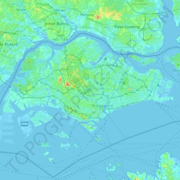
Name: Singapore topographic map, elevation, terrain.
Location: Singapore, Central, Singapore (1.21013 103.60567 1.47156 104.04364)
Average elevation: 11 m
Minimum elevation: -6 m
Maximum elevation: 166 m
Other topographic maps
Click on a map to view its topography, its elevation and its terrain.
Fort Canning Park
Singapore > Central > Singapore
The hill has a long history intertwined with that of the country due to its location as the highest elevation within walking distance to the city's civic district, within the Downtown Core. It is also a popular location for exhibitions, concerts and outdoor recreation.
Average elevation: 19 m