Tavas topographic map
Interactive map
Click on the map to display elevation.
Tavas topographic map, elevation, terrain
About this map
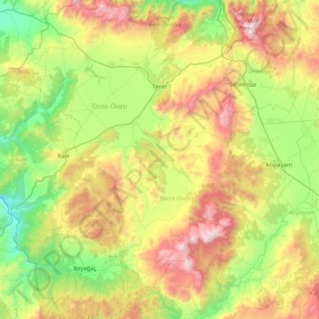
Name: Tavas topographic map, elevation, terrain.
Location: Tavas, Denizli, Aegean Region, Turkey (37.13957 28.74777 37.73232 29.25576)
Average elevation: 1,125 m
Minimum elevation: 387 m
Maximum elevation: 2,515 m
Other topographic maps
Click on a map to view its topography, its elevation and its terrain.
Devrek
Devrek is located in an altitude of 86 meters. It is 56 km from Zonguldak, 210 km from Ankara and 370 km from Istanbul. It is surrounded by mountains, the most notable ones being Babadağı, Göldağı, Akçasu and Yenice. The most important river passing through the region is Devrek creek. Devrek creek joins…
Average elevation: 577 m
Erdek
Erdek (formerly known as Artàke, Greek: Αρτάκη) is a municipality and district of Balıkesir Province, Turkey. Its area is 307 km2, and its population is 31,902 (2022). Located on the Kapıdağ Peninsula, on the north coast of the Gulf of Erdek at the south of the Sea of Marmara, Erdek is a popular…
Average elevation: 68 m
Istanbul
Because of its hilly topography and maritime influences, Istanbul exhibits a multitude of distinct microclimates. Within the city, rainfall varies widely owing to the rain shadow of the hills in Istanbul, from around 600 millimeters (24 in) on the southern fringe at Florya to 1,200 millimeters (47 in) on the…
Average elevation: 57 m
Ankara
Ankara has a cold semi-arid climate (Köppen climate classification: BSk). Under the Trewartha climate classification, Ankara has a temperate humid continental climate (Dc). Due to its elevation and inland location, Ankara has cold and snowy winters, and hot and dry summers. Rainfall occurs mostly during the…
Average elevation: 1,082 m
Gaziantep
The plan introduced several important changes to the city's transportation network. One of the most important was the addition of a rail line to connect Gaziantep to the national rail system. Up to now, Turkish railway construction had ignored Gaziantep (partly because of its mountainous surroundings); a…
Average elevation: 880 m
Ardahan
Ardahan province is located in the far north east of Turkey, where the eastern extremity of the high plateau of Eastern Anatolia converges with the Lesser Caucasus mountain range. It is consequently an area of very high altitude and severe winters. This is attractive open countryside which however spends many…
Average elevation: 2,008 m
Adana
Aladağlar National Park, located north of Adana, is a huge park of around 55,000 hectares, the summit of Demirkazik at 3756m is the highest point in the middle Taurus mountain range. There is a huge range of flora and fauna, and visitors may fish in the streams full of trout. Wildlife includes wild goats,…
Average elevation: 879 m
Kaş
As the tenth most populous district of Antalya as of 2022, Kaş is on a hill running down to the Turquoise Coast of southwestern Turkey. The district has a typical Mediterranean climate of hot, dry summers and mild, wet winters, which allows the growth of oranges, lemons and bananas. The lowland areas are also…
Average elevation: 837 m
Batman
The province occupies an area of 4,477 km2 (1,729 sq mi). It lies in a mountainous area with the average elevation of 550 meters which contains several thousands of caves. The tallest mountains are Sason Dağları (2500 m), Meleto (2967 m), Kuşaklı Dağı (1947 m), Avcı Dağı (2121 m), Meydanok Tepesi…
Average elevation: 941 m