
Ordu topographic map
Click on the map to display elevation.
Ordu
Ordu is a strip of Black Sea coast and the hills behind, historically an agricultural and fishing area and in recent years, tourism has seen an increase, mainly visitors from Russia and Georgia, as Ordu boasts some of the best beaches, rivers, and lush, green mountains on the Black Sea coast. Walking in the high pastures is now a popular excursion for Turkish holidaymakers. The higher altitudes are covered in forest.
About this map
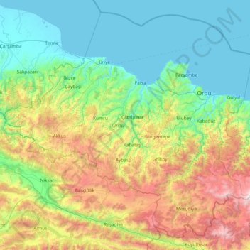
Name: Ordu topographic map, elevation, terrain.
Location: Ordu, Black Sea Region, Turkey (40.33057 36.68241 41.34600 38.16794)
Average elevation: 705 m
Minimum elevation: -2 m
Maximum elevation: 2,997 m
Other topographic maps
Click on a map to view its topography, its elevation and its terrain.
Gaziantep
The plan introduced several important changes to the city's transportation network. One of the most important was the addition of a rail line to connect Gaziantep to the national rail system. Up to now, Turkish railway construction had ignored Gaziantep (partly because of its mountainous surroundings); a…
Average elevation: 880 m
Mihalıççık
Turkey > Mihalıççık > Mihalıççık
Mihalıççık, also Mihalıçcık (English: Micalizo, sometimes Mihaliccik), is a town and district of Eskişehir Province in the Central Anatolia region of Turkey. According to 2010 census, population of the district is 10,482 of which 3,133 live in the town of Mihalıççık. The district covers an area of…
Average elevation: 1,284 m