
Gloucester County topographic map
Interactive map
Click on the map to display elevation.
About this map
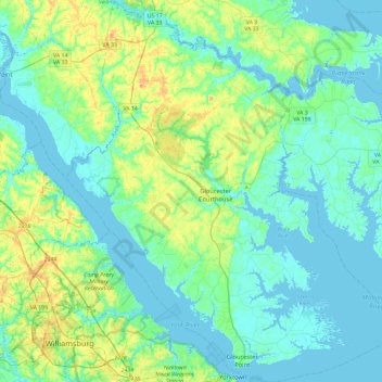
Name: Gloucester County topographic map, elevation, terrain.
Location: Gloucester County, Virginia, United States (37.23332 -76.71231 37.60321 -76.30450)
Average elevation: 13 m
Minimum elevation: -5 m
Maximum elevation: 57 m
Other topographic maps
Click on a map to view its topography, its elevation and its terrain.
McAfee Knob
United States > Virginia > Roanoke County
McAfee Knob is a geological feature with an elevation of 3,197 feet (974 m) above sea level, located on Catawba Mountain in Catawba, Virginia, roughly 15 miles northwest of Downtown Roanoke. It is named for a Scottish-Irish 18th-century settler. Considered to be among the most iconic points along the…
Average elevation: 657 m
Lucketts Community Center
United States > Virginia > Loudoun County > Lucketts
Average elevation: 101 m
Cumberland Gap
United States > Virginia > Lee County
The Cumberland Gap is a pass in the eastern United States through the long ridge of the Cumberland Mountains, within the Appalachian Mountains and near the tripoint of Kentucky, Virginia, and Tennessee. At an elevation of 1,631 feet (497 m) above sea level, it is famous in American colonial history for its…
Average elevation: 512 m
Burgundy Village
United States > Virginia > Fairfax County > Rose Hill > Burgundy Village
Average elevation: 35 m
North Fairlington
United States > Virginia > Arlington County > Arlington > North Fairlington
Average elevation: 54 m