Geolocate

Salisbury topographic map

Click on the map to display elevation.

About this map

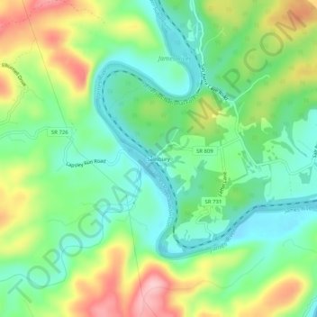
Name: Salisbury topographic map, elevation, terrain.

Location: Salisbury, Botetourt County, Virginia, United States (37.58763 -79.80227 37.62763 -79.76227)

Average elevation: 330 m

Minimum elevation: 263 m

Maximum elevation: 447 m

Gear up for your next adventure:

🥾Waterproof Trail Shoes - Shoes designed to handle wet terrain
🔋Emergency Crank Radio - Weather alerts and power without needing batteries
🥾Hiking Shoes - Durable and comfortable shoes for trail hiking
🚲MTB Frame Bag - Carry tools and maps directly on your bicycle frame
🥾Waterproof Hiking Boots - Boots keeping your feet dry in wet conditions

As an Amazon Associate, this site earns from qualifying purchases at no extra cost to you.