Geolocate

Leesville topographic map

Click on the map to display elevation.

About this map

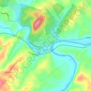
Name: Leesville topographic map, elevation, terrain.

Location: Leesville, Campbell County, Virginia, 24571, United States (37.09905 -79.40665 37.13905 -79.36665)

Average elevation: 205 m

Minimum elevation: 158 m

Maximum elevation: 291 m

Gear up for your next adventure:

🧼Biodegradable Camp Soap - Environmentally friendly cleaning for gear and body
🦶Hiking Shoe Insoles - Added support for high arches and long days on feet
Camping Tent - Weather-resistant tents suitable for 2 to 6 people
Family Camping Tent - Spacious tent suitable for family camping trips
🧢Outdoor Visor - Breathable visor for sunny hikes

As an Amazon Associate, this site earns from qualifying purchases at no extra cost to you.