
Make a donation
Gear up for your next adventure:
As an Amazon Associate, this site earns from qualifying purchases at no extra cost to you.
McAfee Knob topographic map
Click on the map to display elevation.
Make a donation
Gear up for your next adventure:
As an Amazon Associate, this site earns from qualifying purchases at no extra cost to you.
McAfee Knob
McAfee Knob is a geological feature with an elevation of 3,197 feet (974 m) above sea level, located on Catawba Mountain in Catawba, Virginia, roughly 15 miles northwest of Downtown Roanoke. It is named for a Scottish-Irish 18th-century settler. Considered to be among the most iconic points along the Appalachian Trail, the vista offers panoramic views of the Catawba Valley, 1,600 feet (490 m) below.
Make a donation
Gear up for your next adventure:
As an Amazon Associate, this site earns from qualifying purchases at no extra cost to you.
About this map
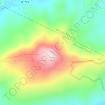
Name: McAfee Knob topographic map, elevation, terrain.
Location: McAfee Knob, Roanoke County, Virginia, United States (37.39262 -80.03687 37.39272 -80.03677)
Average elevation: 657 m
Minimum elevation: 461 m
Maximum elevation: 955 m
Make a donation
Gear up for your next adventure:
As an Amazon Associate, this site earns from qualifying purchases at no extra cost to you.