
Viken topographic map
Interactive map
Click on the map to display elevation.
About this map
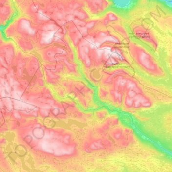
Name: Viken topographic map, elevation, terrain.
Location: Hemsedal, Viken, 3560, Norway (60.76404 8.04087 61.09172 8.91900)
Average elevation: 1,217 m
Minimum elevation: 417 m
Maximum elevation: 1,920 m
Other topographic maps
Click on a map to view its topography, its elevation and its terrain.
Halti
Halti (Finnish: Halti, rarely Haltiatunturi, Northern Sami: Háldičohkka, Swedish: Haldefjäll) is a fell at the border between Norway and Finland. The peak (elevation 1,365 m (4,478 ft)) of the fell, called Ráisduattarháldi, is in Norway, on the border between the municipalities of Nordreisa and…
Average elevation: 1,192 m
Bodø
Snow cover during winter varies, and is often sparse or lacking in the city center, while being more reliable only slightly inland or at some altitude. The largest recorded snow depth at the airport is 90 centimetres (35 in) in February 1976. Located on a peninsula in the Norwegian Sea, Bodø is known to be a…
Average elevation: 74 m