Geolocate

Ausland topographic map

Click on the map to display elevation.

About this map

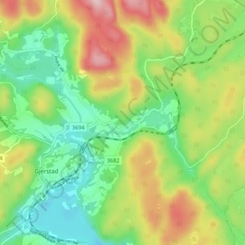
Name: Ausland topographic map, elevation, terrain.

Location: Ausland, Gjerstad, Agder, Norway (58.86912 9.02356 58.90912 9.06356)

Average elevation: 127 m

Minimum elevation: 22 m

Maximum elevation: 295 m

Gear up for your next adventure:

🛶Kayak Accessories - Essential gear for safe and fun kayaking adventures
🎒Hiking Daypack - Lightweight and durable backpacks for day trips and excursions
🔋Emergency Crank Radio - Weather alerts and power without needing batteries
🥾Waterproof Hiking Shoes - Durable shoes for wet and rugged trails
🦶Anti-Blister Balm - Prevents friction and hotspots during long ascents

As an Amazon Associate, this site earns from qualifying purchases at no extra cost to you.